"A visit to West Yorkshire's very own 'Lake District', now a bird reserve of national importance."
Walk directions
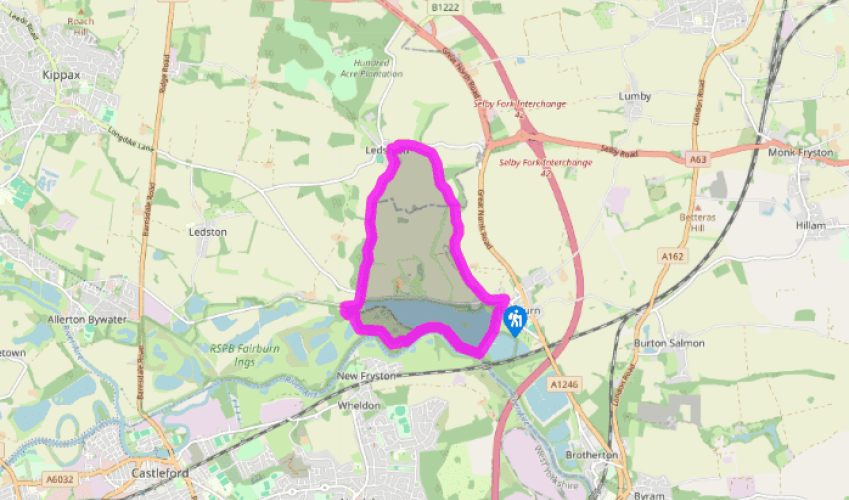
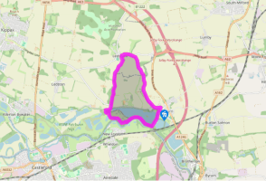
Walk down Cut Road. After passing through a gate, the way narrows to a wooded causeway between the lakes, from which a short detour leads to a bird hide over on the left. The route, however, remains with the main path, crossing a bridge and eventually leading to a junction overlooking the River Aire.
Go right through a kissing gate along the top of a wooded ridge (actually an old spoil heap), which separates the river from the lake. Look out for a couple of other bird hides before you lose sight of the lake. As the ridge broadens, the path diverges from the river. Later falling, it curves to join a track above a smaller lake. Follow it down right to a metal gate and go left in front of it through a kissing gate. After 100yds (91m), opposite a sculpted frog, turn right on a walkway that winds across a marsh to the visitor centre. Swing right through the car park to a lane.
Go right to a junction and turn left towards Ledston and Kippax. However, after just 100yds (91m), take a path on your right that hugs the right-hand fringe of a wood. Beyond the trees, the way continues between fields, broadening to a track as it nears Ledsham. Emerging onto Manor Garth, go right to the main lane in front of the church.
The Chequers Inn lies a short distance to the left. The return route, however, winds to the right around the church and through the village. After 200yds (183m), on a left bend, leave ahead through a gate onto an undulating track. Over a stile, walk towards woodland and continue within its periphery. Beyond another stile, keep going beside the trees and then at the bottom of a pasture. A stile left of the corner takes the way through a narrow spur of woodland.
Head slightly left, uphill, across the next field, to follow a fence and hedgerow bounding the top. Keep ahead through kissing gates, remaining at the field edge and passing barns that stand over to the left. Through a final gate, a developing track leads downhill. Go left, when you eventually meet the road, back into the village of Fairburn.
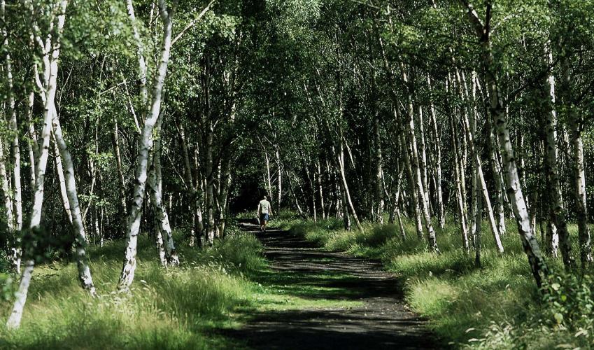
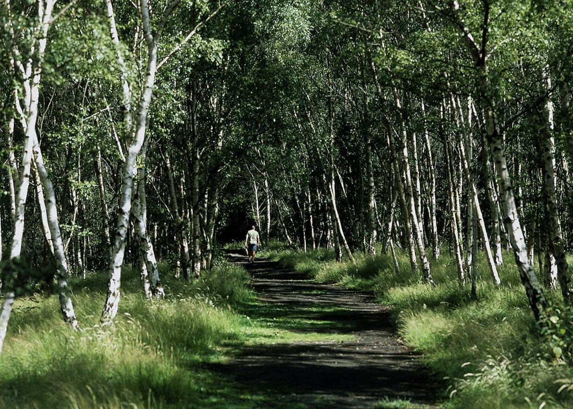
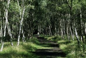
The coalfields of West Yorkshire were most concentrated in the borough of Wakefield. Towns and villages grew up around the mines and came to represent the epitome of northern industrial life. Mining was always a dangerous and dirty occupation, and it changed the landscape dramatically. Opencast... mines swallowed up huge tracts of land, and the extensive spoil heaps were all-too-visible evidence of industry. For the men of these communities, mining was almost the only work available. When the industry went into decline, these communities were hit especially hard. The mining industry was decimated and thousands of miners lost their livelihoods. The death of the industry was emphasised by the closing down of Caphouse Colliery and its subsequent conversion into the National Coal Mining Museum for England. The spoil heaps that scarred the landscape are going back to nature, a process hastened by tree planting and other reclamation schemes. Opencast workings have been transformed into lakes and wetlands – valuable havens for wildfowl and migrating birds. Within a single generation, West and South Yorkshire has achieved a network of lakes to rival the Norfolk Broads, surrounded by wild plants and woodland that attracts many insects, small animals and birds. Fairburn Ings, now under the stewardship of the Royal Society for the Protection of Birds (RSPB), was one of the earliest examples of colliery reclamation – being designated a Local Nature Reserve in 1957. The result is arguably the most important nature reserve in West Yorkshire. Superficially, the site might seem unpromising; in proximity to the A1(M), the conurbation of Castleford, the River Aire, a railway and former spoil heaps. Nevertheless, the stark outlines of the spoil heaps are now softened by banks of silver birch, and mining subsidence has created a broad expanse of water near the village of Fairburn, as well as smaller pools and flashes. There are plenty of birds to be seen at all times of the year, though the numbers of ducks, geese, swans and gulls are at their highest during the winter months. The 600 acres (243ha) of wetlands are a magnet for birds during the spring and autumn migration. In summer, there are many species of wildlife nesting on the scrapes and islands – including terns and a large, noisy colony of black-headed gulls. The best places from which to view all this activity are the public hides that overlook the lake. Hidden away from the traffic hammering up and down the nearby motorway, the estate village of Ledsham is a tranquil little backwater. Behind the Saxon church – one of the oldest in West Yorkshire – is a row of picturesque almshouses and the village has an old and characterful country pub, the Chequers Inn.
Everybody knows that Yorkshire has some special landscapes. The Dales and the Moors first spring to mind, but what about West Yorkshire? That’s Leeds and Bradford isn’t it? Back-to-back houses and blackened mills… Certainly if you had stood on any of the hills surrounding Hebden Bridge a hundred years ago, and gazed down into the valley, all you would have seen was the pall of smoke issuing from the chimneys of 33 textile mills.
"A visit to West Yorkshire's very own 'Lake District', now a bird reserve of national importance."
Walk details
1hrs 45min
Difficulty:
Easy
Gradient:
Gentle
Distance:
5 miles (8kms)
Ascent:
262ft (80m)
Walk directions
Walk down Cut Road. After passing through a gate, the way narrows to a wooded causeway between the lakes, from which a short detour leads to a bird hide over on the left. The route, however, remains with the main path, crossing a bridge and eventually leading to a junction overlooking the River Aire.
1 of 5
Go right through a kissing gate along the top of a wooded ridge (actually an old spoil heap), which separates the river from the lake. Look out for a couple of other bird hides before you lose sight of the lake. As the ridge broadens, the path diverges from the river. Later falling, it curves to join a track above a smaller lake. Follow it down right to a metal gate and go left in front of it through a kissing gate. After 100yds (91m), opposite a sculpted frog, turn right on a walkway that winds across a marsh to the visitor centre. Swing right through the car park to a lane.
2 of 5
Go right to a junction and turn left towards Ledston and Kippax. However, after just 100yds (91m), take a path on your right that hugs the right-hand fringe of a wood. Beyond the trees, the way continues between fields, broadening to a track as it nears Ledsham. Emerging onto Manor Garth, go right to the main lane in front of the church.
3 of 5
The Chequers Inn lies a short distance to the left. The return route, however, winds to the right around the church and through the village. After 200yds (183m), on a left bend, leave ahead through a gate onto an undulating track. Over a stile, walk towards woodland and continue within its periphery. Beyond another stile, keep going beside the trees and then at the bottom of a pasture. A stile left of the corner takes the way through a narrow spur of woodland.
4 of 5
Head slightly left, uphill, across the next field, to follow a fence and hedgerow bounding the top. Keep ahead through kissing gates, remaining at the field edge and passing barns that stand over to the left. Through a final gate, a developing track leads downhill. Go left, when you eventually meet the road, back into the village of Fairburn.
The coalfields of West Yorkshire were most concentrated in the borough of Wakefield. Towns and villages grew up around the mines and came to represent the epitome of northern industrial life. Mining was always a dangerous and dirty occupation, and it changed the landscape dramatically. Opencast... mines swallowed up huge tracts of land, and the extensive spoil heaps were all-too-visible evidence of industry. For the men of these communities, mining was almost the only work available. When the industry went into decline, these communities were hit especially hard. The mining industry was decimated and thousands of miners lost their livelihoods. The death of the industry was emphasised by the closing down of Caphouse Colliery and its subsequent conversion into the National Coal Mining Museum for England. The spoil heaps that scarred the landscape are going back to nature, a process hastened by tree planting and other reclamation schemes. Opencast workings have been transformed into lakes and wetlands – valuable havens for wildfowl and migrating birds. Within a single generation, West and South Yorkshire has achieved a network of lakes to rival the Norfolk Broads, surrounded by wild plants and woodland that attracts many insects, small animals and birds. Fairburn Ings, now under the stewardship of the Royal Society for the Protection of Birds (RSPB), was one of the earliest examples of colliery reclamation – being designated a Local Nature Reserve in 1957. The result is arguably the most important nature reserve in West Yorkshire. Superficially, the site might seem unpromising; in proximity to the A1(M), the conurbation of Castleford, the River Aire, a railway and former spoil heaps. Nevertheless, the stark outlines of the spoil heaps are now softened by banks of silver birch, and mining subsidence has created a broad expanse of water near the village of Fairburn, as well as smaller pools and flashes. There are plenty of birds to be seen at all times of the year, though the numbers of ducks, geese, swans and gulls are at their highest during the winter months. The 600 acres (243ha) of wetlands are a magnet for birds during the spring and autumn migration. In summer, there are many species of wildlife nesting on the scrapes and islands – including terns and a large, noisy colony of black-headed gulls. The best places from which to view all this activity are the public hides that overlook the lake. Hidden away from the traffic hammering up and down the nearby motorway, the estate village of Ledsham is a tranquil little backwater. Behind the Saxon church – one of the oldest in West Yorkshire – is a row of picturesque almshouses and the village has an old and characterful country pub, the Chequers Inn.
Everybody knows that Yorkshire has some special landscapes. The Dales and the Moors first spring to mind, but what about West Yorkshire? That’s Leeds and Bradford isn’t it? Back-to-back houses and blackened mills… Certainly if you had stood on any of the hills surrounding Hebden Bridge a hundred years ago, and gazed down into the valley, all you would have seen was the pall of smoke issuing from the chimneys of 33 textile mills.