"Vast skylines and endless reed-choked marshes make you feel very small in this fascinating landscape."
Walk directions
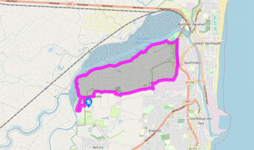
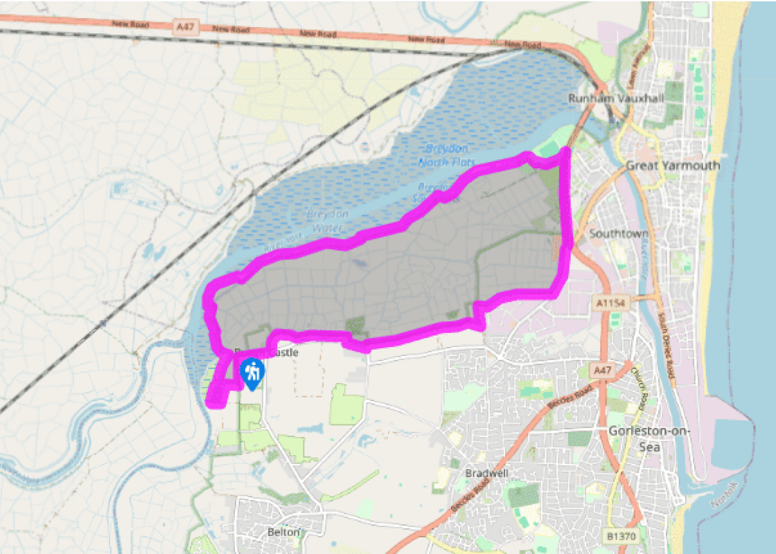
Leave the Burgh Castle car park on Butt Lane and take the footpath towards the church. At the churchyard, turn left onto a track. After a few steps and a kissing gate, you will see a well-trodden path cutting diagonally across the fields. Follow this path until you reach the spectacularly grand and well-preserved walls of the Roman fort Gariannonum, aiming for the gap in the middle.
Go through the gap to explore the castle, then aim for 28 steps in the far right-hand corner. Descend the steps, walk alongside a field, and look for 40 steps leading down to the river bank. Turn right along the Angles Way and continue until you reach a junction of paths behind Church Farm. This stretch of riverside and reedbeds may be flooded after heavy rain.
Turn left towards the double gates, which will take you on a long (3-mile/4.8km) uninterrupted trail along the edge of Breydon Water. The path sticks closely by the river, following a raised flood bank with glorious views in all directions across the pancake-flat marshes and mudflats. Eventually, you will see the tall struts of Breydon Bridge in the distance.
Pass through a gate to enter the Herbert Barnes Riverside Park. When the path divides, take the right-hand fork, leaving the river and winding across a meadow to Broadland Rugby Club, where you climb to the A12.
If you want to avoid a busy stretch of main road, turn around at this point and retrace your steps along the river, enjoying the views of Breydon Water in the opposite direction. Otherwise, turn right on the A12, keeping carefully to the right-hand verge, and continue for just over 0.5 miles (800m) to a roundabout with Gapton Hall Retail Park on your right. Keep right on a pedestrian and cycle path beside the road. After passing the entrance signs for Bradwell and just before an industrial estate, look for a gap in the hedge and steps leading down to a bridleway across the marshes on your right.
Turn down the footpath, which takes you between the estate and the marshes. After 0.75 miles (1.2km), turn left onto a wide track for about 250yds (229m), then take a footpath through a gap in the hedge to your right, past the farm buildings of Bradwell Hall, to a crossroads.
Keep ahead through a rusty gate and pass to the left of an abandoned house, then follow the path between the fields. Cross a stile and go across the field to another stile and a short farm track, which bends left to arrive at High Road. Turn right, and right again on to Back Lane. This quiet lane bends left, passing houses and an Anglian Water station, before emerging onto High Road at the Queens Head.
Turn right and then take the next left onto Butt Lane, back to the car park.
Terrain
- Riverside paths, footpaths, busy stretch of road, several steps
Landscape
- Marshland, expanses of mudflats and some arable land
Dog friendliness
- Must be on lead at all times along edge of Breydon Water
Parking
- Norfolk Archaeological Trust car park on Butt Lane. Groups larger than two cars should ring first to check no other event is taking place (www.norfarchtrust.org.uk)
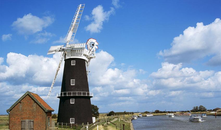
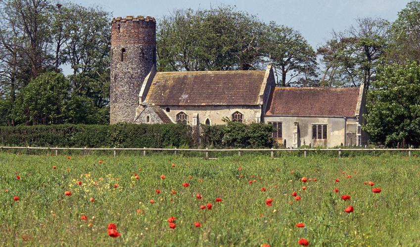
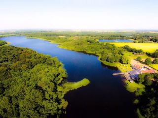
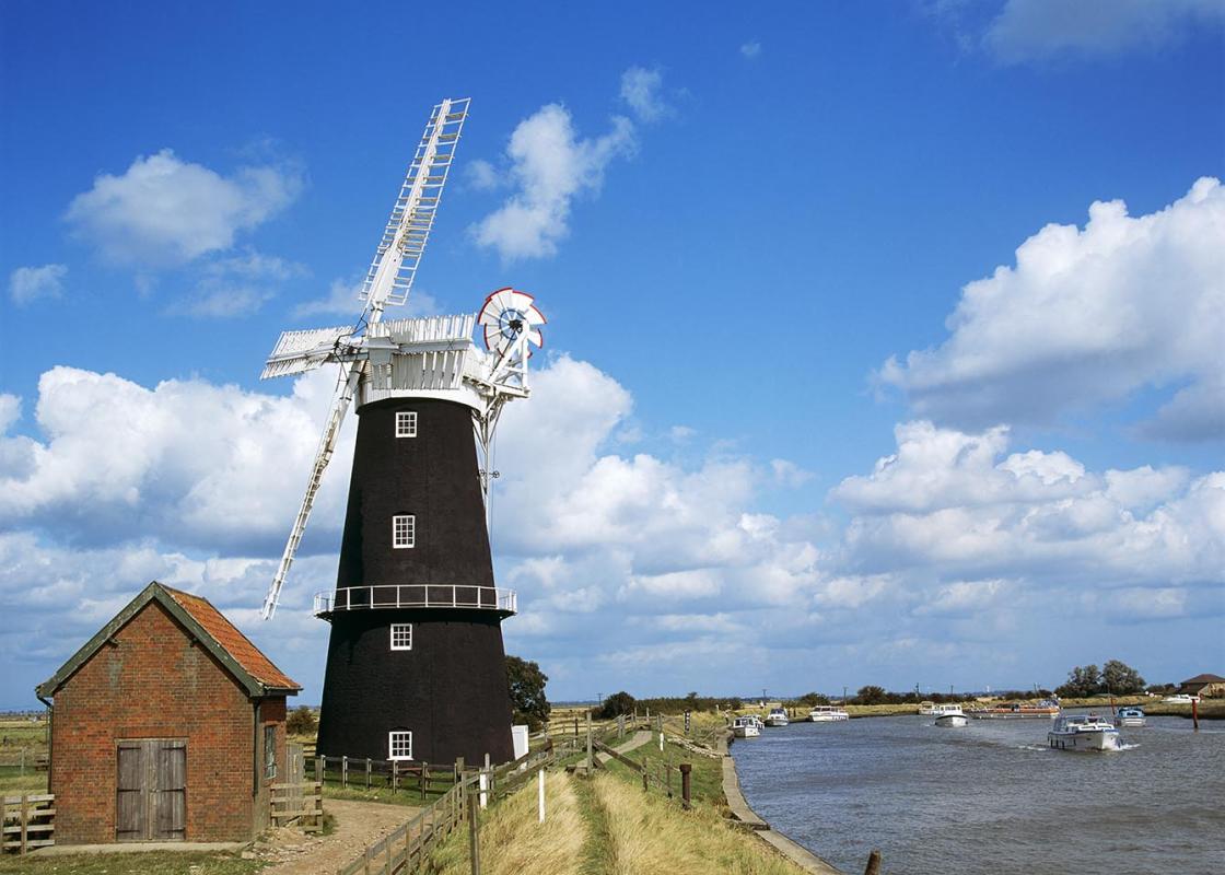
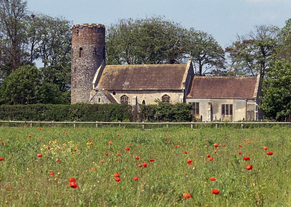
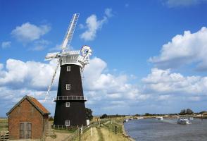
Near the western reaches of Breydon Water there is a Roman fort, a wind pump owned by the National Trust and an atmospheric pub, which is inaccessible to cars. However, there is an obstacle preventing you from wandering to and from these sites: the River Yare. At the start of the walk you will see... the river begin to widen, until it forms the vast, silt-slippery flats of Breydon Water that lies between the Roman castle and the mill and pub – so the only way to see all three on foot is to walk around it! This part of the Broads is perhaps the most mysterious and lonely of all, and the fact that few roads cross the marshes that radiate out from Breydon Water means that it is generally people-free. This suits birds very nicely, and the Royal Society for the Protection of Birds (RSPB) manages quite a large part of it, maintaining it as a nature reserve to encourage both rare and common species. Halvergate Marshes, to the west, is an alluvial basin that is home to shovellers, snipe, lapwings, yellow wagtails and redshanks. Berney Arms Mill is one of the most spectacular mills in the country. It is in perfect working order and stands some 70ft (21m) high, making it the tallest marsh mill in Norfolk or Suffolk. It was built in 1870 and now houses a small museum. Downstream is the Berney Arms pub, accessible only to people who walk or navigate the silty channels in their boats. An impressive fortress Gariannonum, or Burgh Castle, is worth a visit and lies on the opposite shore of the river. Originally this would have commanded an imposing position looking towards Caister, but changes in the sea level and silting up have relegated it to a quiet part of the river. It was built in the 3rd century AD to defend the Roman province from marauding Saxons, and was an impressive fortress. Even today, visitors will see walls rising to more than 15ft (4.5m). This stronghold is said to have been the place where the Irish missionary St Fursey arrived in England in about AD 630. One of the first things he did was to found a monastery, which he called Cnobheresburg, although nothing remains of this today. Later, Fursey removed himself to France, so that he could become a proper hermit. He founded a monastery near Paris and when he died, his body declined to rot. He was declared a saint, and various parts of his corpse toured the country until most were destroyed during the French Revolution. The head was said to have survived, though, and is still an object of reverence in Péronne, in Picardy.
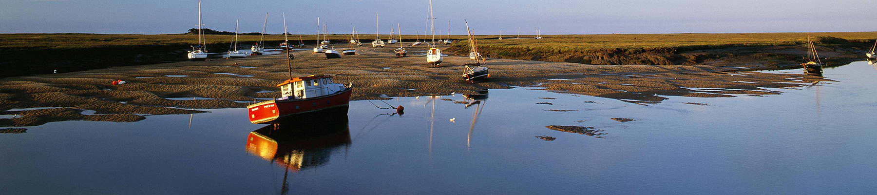
The North Norfolk Coast is designated an Area of Outstanding Natural Beauty and probably the finest of its kind in Europe. Here you’ll find a string of quaint villages and small towns – Holkham, Wells-next-the-Sea and Cley next the Sea are 21st-century favourites, while Sheringham and Cromer are classic examples of a good old-fashioned seaside resort where grand Victorian hotels look out to sea.
"Vast skylines and endless reed-choked marshes make you feel very small in this fascinating landscape."
Walk details
3hrs
Difficulty:
Hard
Gradient:
Gentle
Distance:
8 miles (12.9kms)
Ascent:
49ft (15m)
Walk directions
Leave the Burgh Castle car park on Butt Lane and take the footpath towards the church. At the churchyard, turn left onto a track. After a few steps and a kissing gate, you will see a well-trodden path cutting diagonally across the fields. Follow this path until you reach the spectacularly grand and well-preserved walls of the Roman fort Gariannonum, aiming for the gap in the middle.
1 of 8
Go through the gap to explore the castle, then aim for 28 steps in the far right-hand corner. Descend the steps, walk alongside a field, and look for 40 steps leading down to the river bank. Turn right along the Angles Way and continue until you reach a junction of paths behind Church Farm. This stretch of riverside and reedbeds may be flooded after heavy rain.
2 of 8
Turn left towards the double gates, which will take you on a long (3-mile/4.8km) uninterrupted trail along the edge of Breydon Water. The path sticks closely by the river, following a raised flood bank with glorious views in all directions across the pancake-flat marshes and mudflats. Eventually, you will see the tall struts of Breydon Bridge in the distance.
3 of 8
Pass through a gate to enter the Herbert Barnes Riverside Park. When the path divides, take the right-hand fork, leaving the river and winding across a meadow to Broadland Rugby Club, where you climb to the A12.
4 of 8
If you want to avoid a busy stretch of main road, turn around at this point and retrace your steps along the river, enjoying the views of Breydon Water in the opposite direction. Otherwise, turn right on the A12, keeping carefully to the right-hand verge, and continue for just over 0.5 miles (800m) to a roundabout with Gapton Hall Retail Park on your right. Keep right on a pedestrian and cycle path beside the road. After passing the entrance signs for Bradwell and just before an industrial estate, look for a gap in the hedge and steps leading down to a bridleway across the marshes on your right.
5 of 8
Turn down the footpath, which takes you between the estate and the marshes. After 0.75 miles (1.2km), turn left onto a wide track for about 250yds (229m), then take a footpath through a gap in the hedge to your right, past the farm buildings of Bradwell Hall, to a crossroads.
6 of 8
Keep ahead through a rusty gate and pass to the left of an abandoned house, then follow the path between the fields. Cross a stile and go across the field to another stile and a short farm track, which bends left to arrive at High Road. Turn right, and right again on to Back Lane. This quiet lane bends left, passing houses and an Anglian Water station, before emerging onto High Road at the Queens Head.
7 of 8
Turn right and then take the next left onto Butt Lane, back to the car park.
Terrain
- Riverside paths, footpaths, busy stretch of road, several steps
Landscape
- Marshland, expanses of mudflats and some arable land
Dog friendliness
- Must be on lead at all times along edge of Breydon Water
Parking
- Norfolk Archaeological Trust car park on Butt Lane. Groups larger than two cars should ring first to check no other event is taking place (www.norfarchtrust.org.uk)
Near the western reaches of Breydon Water there is a Roman fort, a wind pump owned by the National Trust and an atmospheric pub, which is inaccessible to cars. However, there is an obstacle preventing you from wandering to and from these sites: the River Yare. At the start of the walk you will see... the river begin to widen, until it forms the vast, silt-slippery flats of Breydon Water that lies between the Roman castle and the mill and pub – so the only way to see all three on foot is to walk around it! This part of the Broads is perhaps the most mysterious and lonely of all, and the fact that few roads cross the marshes that radiate out from Breydon Water means that it is generally people-free. This suits birds very nicely, and the Royal Society for the Protection of Birds (RSPB) manages quite a large part of it, maintaining it as a nature reserve to encourage both rare and common species. Halvergate Marshes, to the west, is an alluvial basin that is home to shovellers, snipe, lapwings, yellow wagtails and redshanks. Berney Arms Mill is one of the most spectacular mills in the country. It is in perfect working order and stands some 70ft (21m) high, making it the tallest marsh mill in Norfolk or Suffolk. It was built in 1870 and now houses a small museum. Downstream is the Berney Arms pub, accessible only to people who walk or navigate the silty channels in their boats. An impressive fortress Gariannonum, or Burgh Castle, is worth a visit and lies on the opposite shore of the river. Originally this would have commanded an imposing position looking towards Caister, but changes in the sea level and silting up have relegated it to a quiet part of the river. It was built in the 3rd century AD to defend the Roman province from marauding Saxons, and was an impressive fortress. Even today, visitors will see walls rising to more than 15ft (4.5m). This stronghold is said to have been the place where the Irish missionary St Fursey arrived in England in about AD 630. One of the first things he did was to found a monastery, which he called Cnobheresburg, although nothing remains of this today. Later, Fursey removed himself to France, so that he could become a proper hermit. He founded a monastery near Paris and when he died, his body declined to rot. He was declared a saint, and various parts of his corpse toured the country until most were destroyed during the French Revolution. The head was said to have survived, though, and is still an object of reverence in Péronne, in Picardy.
The North Norfolk Coast is designated an Area of Outstanding Natural Beauty and probably the finest of its kind in Europe. Here you’ll find a string of quaint villages and small towns – Holkham, Wells-next-the-Sea and Cley next the Sea are 21st-century favourites, while Sheringham and Cromer are classic examples of a good old-fashioned seaside resort where grand Victorian hotels look out to sea.