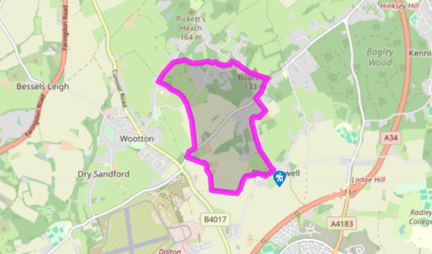
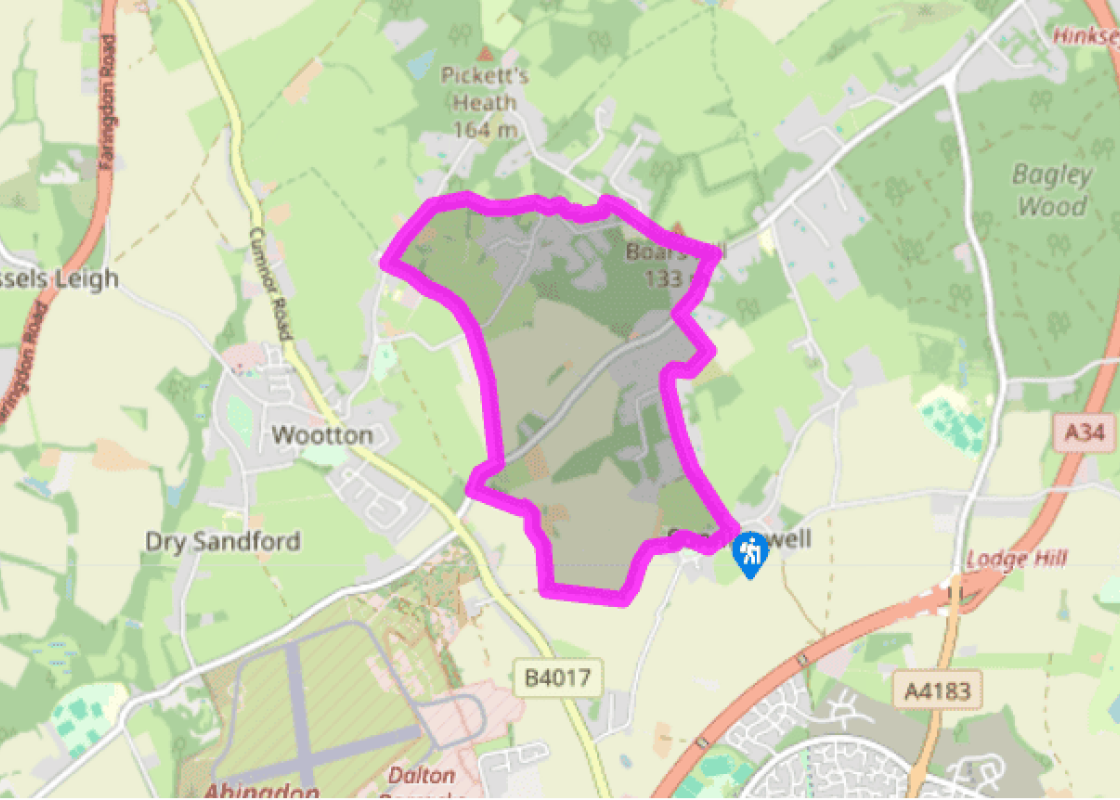
Walk with the church on your left and, as the road bends left, turn right into Dark Lane. Beyond a school the lane becomes a concrete track but, in 50yds (46m), when it curves right, keep left, following a rough track between hedgerows and then across open fields.
After 700yds (640m) turn right towards farm buildings and cut between them. Cross a stile by the gate. A farm track leads out to the road 350yds (320m) distant, but the true right of way runs roughly parallel to it about 20yds (18m) to the left, in the arable field. At Fox Lane turn right. Walk on the verge for about 200yds (183m) and cross over with care to a footpath sign, and to a gate. Cross the open field, pass through a boundary hedge and keep ahead towards a white house. Look for a gap in the field corner beside it and cross the lane to a stile and gate.
Follow the metalled lane to The Linnings, a riding school. Keep to the right of the buildings, crossing three stiles. Go diagonally across the paddock, crossing two stiles over electric fences to reach the boundary hedge. Cross two stiles, avoiding stiles in the left and right boundary of the field, and follow the path beside a high wire fence enclosing a reservoir. Keep ahead at the fence corner to a galvanised gate and chain squeeze gate on the right and follow an enclosed path beside a paddock towards the houses of Wootton. Through a galvanised gate turn right, passing the entrance to Stones Farm.
On reaching the entrance to Wootton End (a house) on the left, keep right here, following a green track. Go through a galvanised gate and keep to the right of a pond. Take a wide fenced path uphill then cross Matthew Arnold’s Field to a kissing gate leading out to the lane. Turn left and walk along to the junction of Jarn Way and Old Boars Hill, ignoring other footpaths. Go straight ahead through the gate and keep left to climb Jarn Mound, then descend the steps and turn left by the seat, keeping the memorial stone on the left. Keep parallel with the road, veer left at the fork and follow the path through the woodland garden for 250yds (229m) to the road. Turn right, pass a house (Ridgeway Cottage) and go down to the junction.
Go straight on, passing a side entrance to Foxcombe Hall, (Peking University HSBC Business School). There is a clear view of the Sheldonian Theatre and many of Oxford’s other historic landmarks from this stretch of the road. Walk along to the T-junction and turn right. After 400yds (366m) turn left into Lincombe Lane. Follow this good tarmac surface round to the right, pass a footpath and continue for a straight 0.25 miles (400m) to a white gate and a kissing gate. Follow the field path towards Sunningwell church. Go through a gate at the bottom of the field to finish the walk.
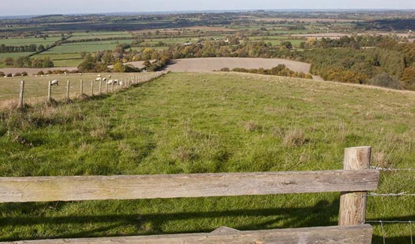
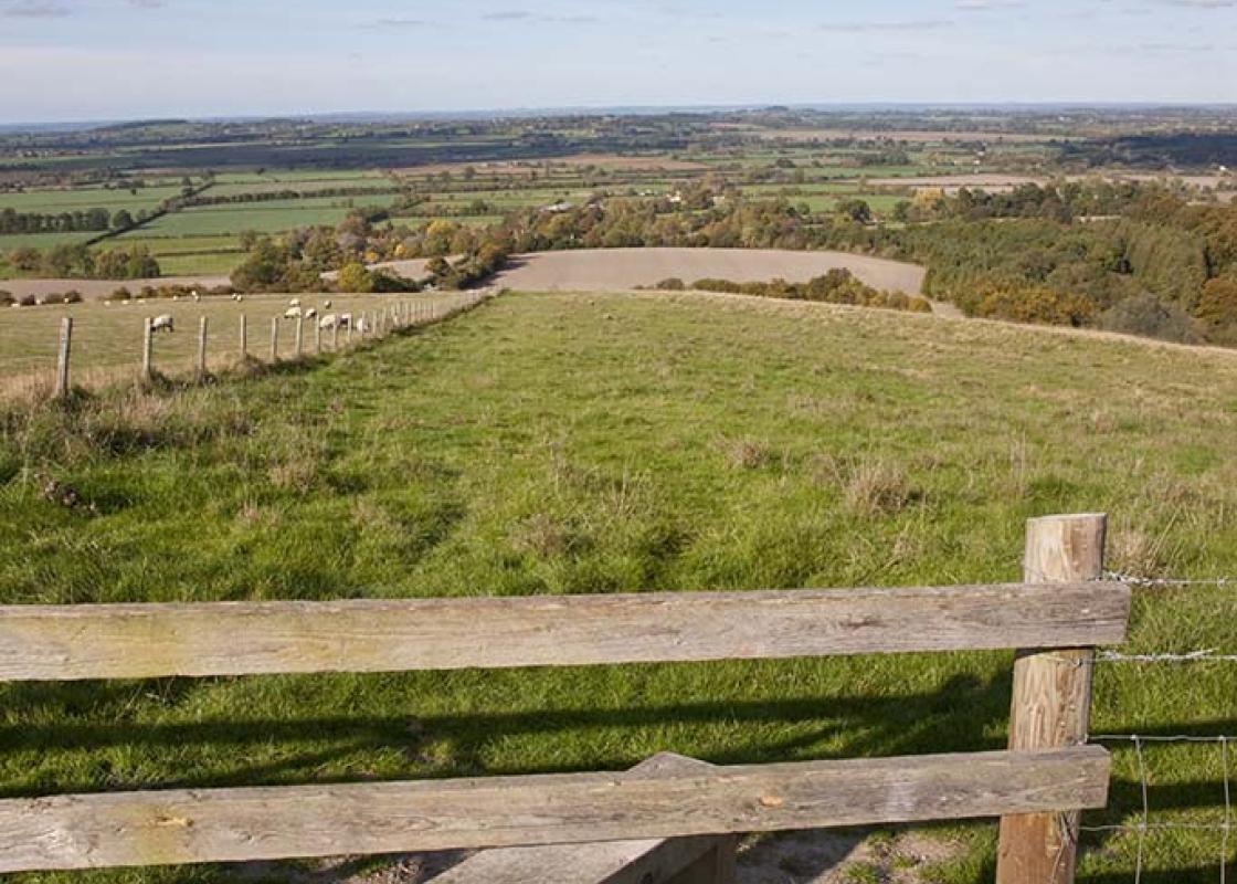
When local resident and renowned archaeologist Sir Arthur Evans (1851–1941) built Jarn Mound, it was with the intention of providing a panoramic view across Oxfordshire towards the neighbouring counties of Warwickshire and Berkshire. However, if Evans were to climb the steps to this noted viewpoint... today, he would be dismayed to discover trees and modern housing development had radically changed the character of the landscape. It was in 1928 that the Oxford Preservation Trust purchased 64 acres (26ha) of land on Boars Hill in order to preserve the view of Oxford and its ‘dreaming spires’. With the support of the Trust, Evans pledged to create an artificial mound to provide a wider view of the area. For as long as anyone could remember, the site had been known locally as Jarn. This was possibly a corruption of the French word for garden. Despite huge problems, including constant soil slippage, work on the mound was eventually finished. It took nearly three years and was completed in November 1931. The task was perfect for Evans, the epitomal archaeologist, and he revelled in the challenge of erecting a 50ft- (15m) high mound. On the summit was placed the dial plate indicating the distances between the mound and significant places of interest in the area. A bowl of freshly minted coins was placed inside. But Evans didn’t stop there. He was keen to enclose the mound so that it blended with its surroundings, and to achieve this his next project was to establish a wild garden of British plants, having first gained the approval of the Oxford Preservation Trust. He imported appropriate soils to allow a variety of native flora to thrive here. The pit created by the building of the mound was transformed into rock and bog gardens and a pond, which was partly re-excavated in 1992. While not much can be done about the housing development that, he might say, blots the landscape, the trees that were growing on the mound itself, restricting the very view it was intended to permit, have been cut back to allow a broad vista once more.
Located at the heart of England, Oxfordshire enjoys a rich heritage and varied scenery, with Oxford’s elegant streets a highlight for visitors. The landscape encompasses open chalk downland, picturesque rivers and attractive villages, while northwest of Oxfordshire is home to the sleepy backwaters of Abingdon, Wallingford, Wantage, Watlington and Witney that reveal how Oxfordshire’s old towns evolved over the centuries.
Walk with the church on your left and, as the road bends left, turn right into Dark Lane. Beyond a school the lane becomes a concrete track but, in 50yds (46m), when it curves right, keep left, following a rough track between hedgerows and then across open fields.
1 of 5
After 700yds (640m) turn right towards farm buildings and cut between them. Cross a stile by the gate. A farm track leads out to the road 350yds (320m) distant, but the true right of way runs roughly parallel to it about 20yds (18m) to the left, in the arable field. At Fox Lane turn right. Walk on the verge for about 200yds (183m) and cross over with care to a footpath sign, and to a gate. Cross the open field, pass through a boundary hedge and keep ahead towards a white house. Look for a gap in the field corner beside it and cross the lane to a stile and gate.
2 of 5
Follow the metalled lane to The Linnings, a riding school. Keep to the right of the buildings, crossing three stiles. Go diagonally across the paddock, crossing two stiles over electric fences to reach the boundary hedge. Cross two stiles, avoiding stiles in the left and right boundary of the field, and follow the path beside a high wire fence enclosing a reservoir. Keep ahead at the fence corner to a galvanised gate and chain squeeze gate on the right and follow an enclosed path beside a paddock towards the houses of Wootton. Through a galvanised gate turn right, passing the entrance to Stones Farm.
3 of 5
On reaching the entrance to Wootton End (a house) on the left, keep right here, following a green track. Go through a galvanised gate and keep to the right of a pond. Take a wide fenced path uphill then cross Matthew Arnold’s Field to a kissing gate leading out to the lane. Turn left and walk along to the junction of Jarn Way and Old Boars Hill, ignoring other footpaths. Go straight ahead through the gate and keep left to climb Jarn Mound, then descend the steps and turn left by the seat, keeping the memorial stone on the left. Keep parallel with the road, veer left at the fork and follow the path through the woodland garden for 250yds (229m) to the road. Turn right, pass a house (Ridgeway Cottage) and go down to the junction.
4 of 5
Go straight on, passing a side entrance to Foxcombe Hall, (Peking University HSBC Business School). There is a clear view of the Sheldonian Theatre and many of Oxford’s other historic landmarks from this stretch of the road. Walk along to the T-junction and turn right. After 400yds (366m) turn left into Lincombe Lane. Follow this good tarmac surface round to the right, pass a footpath and continue for a straight 0.25 miles (400m) to a white gate and a kissing gate. Follow the field path towards Sunningwell church. Go through a gate at the bottom of the field to finish the walk.
When local resident and renowned archaeologist Sir Arthur Evans (1851–1941) built Jarn Mound, it was with the intention of providing a panoramic view across Oxfordshire towards the neighbouring counties of Warwickshire and Berkshire. However, if Evans were to climb the steps to this noted viewpoint... today, he would be dismayed to discover trees and modern housing development had radically changed the character of the landscape. It was in 1928 that the Oxford Preservation Trust purchased 64 acres (26ha) of land on Boars Hill in order to preserve the view of Oxford and its ‘dreaming spires’. With the support of the Trust, Evans pledged to create an artificial mound to provide a wider view of the area. For as long as anyone could remember, the site had been known locally as Jarn. This was possibly a corruption of the French word for garden. Despite huge problems, including constant soil slippage, work on the mound was eventually finished. It took nearly three years and was completed in November 1931. The task was perfect for Evans, the epitomal archaeologist, and he revelled in the challenge of erecting a 50ft- (15m) high mound. On the summit was placed the dial plate indicating the distances between the mound and significant places of interest in the area. A bowl of freshly minted coins was placed inside. But Evans didn’t stop there. He was keen to enclose the mound so that it blended with its surroundings, and to achieve this his next project was to establish a wild garden of British plants, having first gained the approval of the Oxford Preservation Trust. He imported appropriate soils to allow a variety of native flora to thrive here. The pit created by the building of the mound was transformed into rock and bog gardens and a pond, which was partly re-excavated in 1992. While not much can be done about the housing development that, he might say, blots the landscape, the trees that were growing on the mound itself, restricting the very view it was intended to permit, have been cut back to allow a broad vista once more.
Located at the heart of England, Oxfordshire enjoys a rich heritage and varied scenery, with Oxford’s elegant streets a highlight for visitors. The landscape encompasses open chalk downland, picturesque rivers and attractive villages, while northwest of Oxfordshire is home to the sleepy backwaters of Abingdon, Wallingford, Wantage, Watlington and Witney that reveal how Oxfordshire’s old towns evolved over the centuries.