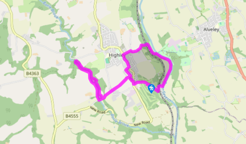
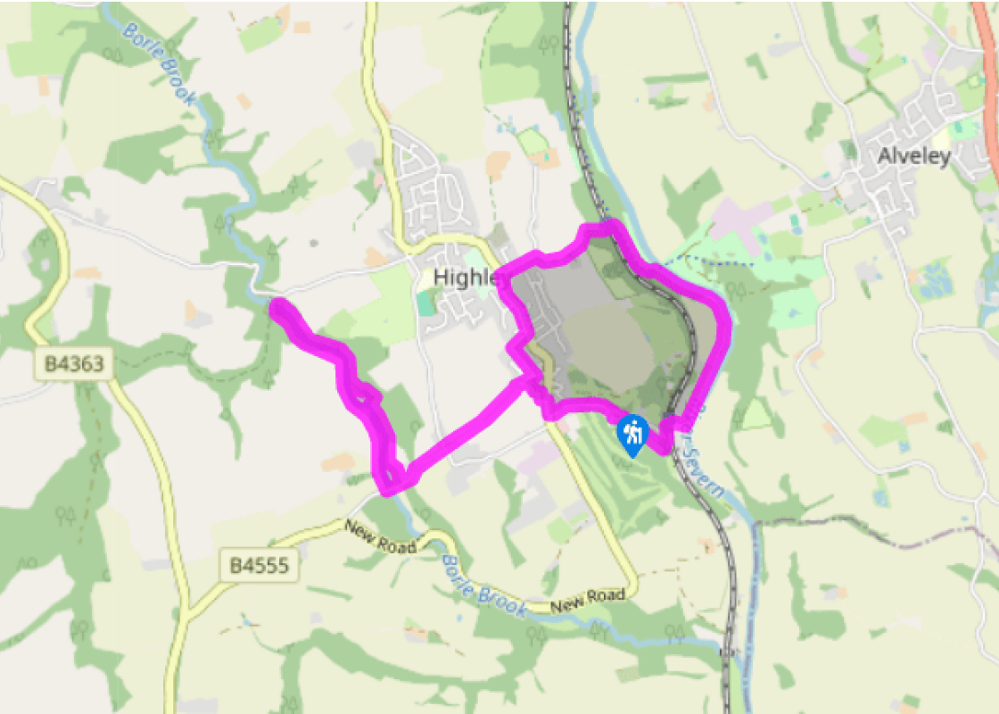
Turn left up Station Road. When you’re almost at the top, turn right at a sign for the Seam Pavement Trail. Follow a footpath (Smoke Alley) to the main road. Turn left, then cross into St Mary’s churchyard.
Go through the churchyard, leaving it by the side of timber framed Church House. Follow a stony track, pass to the left of Springfield and go left on a public footpath which runs along field-edges to a lane. Walk steeply down another lane almost opposite.
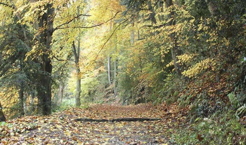
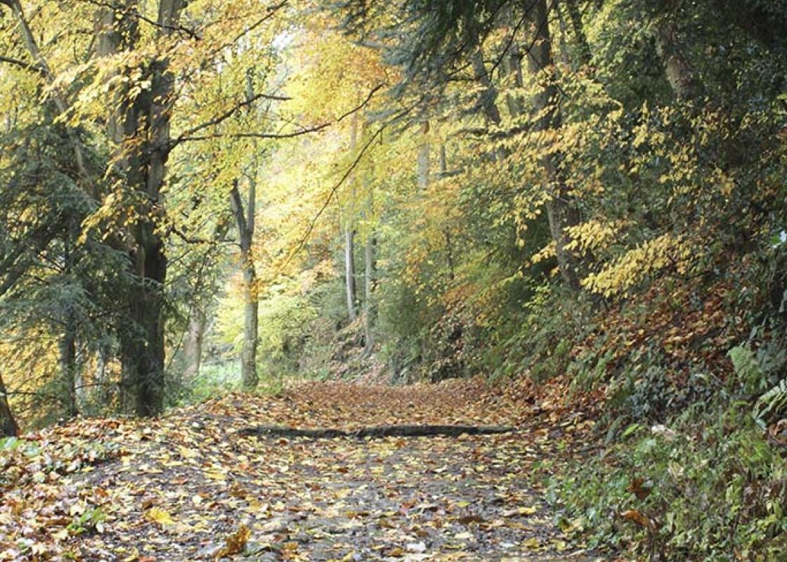
Cross Borlemill Bridge and turn right on a public footpath. It’s hidden among conifers, but it’s opposite an easily seen path on the other side. After passing a house, continue along field-edges and then through the woodland which borders Borle Brook.
The path arrives at Donkey Bridge (an 18th-century packhorse bridge), which you will need to cross. Before you do so, however, it’s worth going a few paces to the left to see an old railway bridge. (If you’re keen to trace the Billingsley Colliery Railway as far as you can, you should turn left on a bridleway which goes to Rays Bridge, but you’ll have to return the same way, owing to the impassability of other footpaths).
Cross Donkey Bridge and go up slightly to a sign-board and picnic tables, then turn right on a well-worn, level path. Follow this, with waymarks appearing wherever they might be needed. Turn left when you come to the lane and retrace your steps to Highley. Pass to the left of the church and left again on Church Street. Follow it to High Street (again watching for the pavement trail plaques) and turn left.
Opposite the Severn Centre, turn right on Vicarage Lane, which will take you past four 400-year-old pollarded beeches, known locally as the Seven Sisters (some say there were once seven trees, others say it’s Severn Sisters), to a junction where you fork right over a cattle grid. The track descends to four gates. Go through the one on the right and continue down.
Cross the railway by Country Park Halt and turn right on a good track. At a junction with a surfaced track, turn left to a new footbridge on the site of the former 1937 Miners’ Bridge. Don’t cross but descend to the riverbank and continue downstream. When you reach The Ship Inn, built for bargemen and opened in 1770, turn right to Highley Station. Cross the line, then turn left until you come to a path climbing through woods. This is the former tramway and it goes directly up taking you back to the car park.
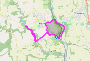
The first thing to say about this walk is yes, it is a weird shape! That’s purely because of the appalling state of some of the other local footpaths, but don’t let that put you off. The paths on this route are fine and it’s an excellent walk in beautiful countryside. You don’t expect to find... mining towns in Shropshire, but Highley is one, albeit in miniature. An ex-mining town, to be precise, but if that conjures up a depressing image, Highley confounds expectation again. Its terraces of well-built, well-preserved and obviously well-loved Victorian houses are trim, attractive and harmonious, their period features mostly intact and their gable walls and window sills all painted bright red in an idiosyncratic touch which may sound disastrous, but actually works perfectly. The Victorian (or possibly Victorian-style) street signs are charming, too. Quarrying was important here long before mining. Although coal mining began in the Middle Ages, large-scale operations commenced only in 1878, peaking in the 1930s. Most of the coal dug at Highley went down a tramway to Highley Station on the Severn Valley Railway (SVR). The tramway is now a footpath, which you’ll follow on this walk. Tramways and railways were built to link other mines to the SVR. Billingsley Colliery Railway ran along the west bank of Borle Brook, joining the SVR at Brooksmouth. A tramway ran along the east bank and both are now footpaths, also used in this walk. The mines closed in 1969 and the former industrial areas on both sides of the river have been transformed into a country park. Highley has also gone in for some public artwork, including a sculpture trail, known as the Seam Pavement Trail, by West Midlands artist Saranjit Birdi. This is a series of seven bronze plaques depicting Highley’s past. The imaginative designs incorporate miners’ nicknames gleaned from archive information and consultation with locals. The names, including such gems as Dick the Devil, Flaming Heck and Joyful Clappers, were passed down through the generations, forming what Saranjit calls a seam through time. The plaques are terrific, with possibly the most striking being Trail Boss, Name Poem and Plough and Lady. The last depicts Lady Godiva (of Coventry fame), who owned Highley Manor in the 11th century. Saranjit Birdi is also responsible for the sculpture A Song of Steam Trains at Highley Station.
Perhaps nowhere else in England will you find a county so deeply rural and with so much variety as Shropshire. Choose a clear day, climb to the top of The Wrekin, and look down on that ‘land of lost content’ so wistfully evoked by A E Housman.
Turn left up Station Road. When you’re almost at the top, turn right at a sign for the Seam Pavement Trail. Follow a footpath (Smoke Alley) to the main road. Turn left, then cross into St Mary’s churchyard.
1 of 7
Go through the churchyard, leaving it by the side of timber framed Church House. Follow a stony track, pass to the left of Springfield and go left on a public footpath which runs along field-edges to a lane. Walk steeply down another lane almost opposite.
2 of 7
Cross Borlemill Bridge and turn right on a public footpath. It’s hidden among conifers, but it’s opposite an easily seen path on the other side. After passing a house, continue along field-edges and then through the woodland which borders Borle Brook.
3 of 7
The path arrives at Donkey Bridge (an 18th-century packhorse bridge), which you will need to cross. Before you do so, however, it’s worth going a few paces to the left to see an old railway bridge. (If you’re keen to trace the Billingsley Colliery Railway as far as you can, you should turn left on a bridleway which goes to Rays Bridge, but you’ll have to return the same way, owing to the impassability of other footpaths).
4 of 7
Cross Donkey Bridge and go up slightly to a sign-board and picnic tables, then turn right on a well-worn, level path. Follow this, with waymarks appearing wherever they might be needed. Turn left when you come to the lane and retrace your steps to Highley. Pass to the left of the church and left again on Church Street. Follow it to High Street (again watching for the pavement trail plaques) and turn left.
5 of 7
Opposite the Severn Centre, turn right on Vicarage Lane, which will take you past four 400-year-old pollarded beeches, known locally as the Seven Sisters (some say there were once seven trees, others say it’s Severn Sisters), to a junction where you fork right over a cattle grid. The track descends to four gates. Go through the one on the right and continue down.
6 of 7
Cross the railway by Country Park Halt and turn right on a good track. At a junction with a surfaced track, turn left to a new footbridge on the site of the former 1937 Miners’ Bridge. Don’t cross but descend to the riverbank and continue downstream. When you reach The Ship Inn, built for bargemen and opened in 1770, turn right to Highley Station. Cross the line, then turn left until you come to a path climbing through woods. This is the former tramway and it goes directly up taking you back to the car park.
The first thing to say about this walk is yes, it is a weird shape! That’s purely because of the appalling state of some of the other local footpaths, but don’t let that put you off. The paths on this route are fine and it’s an excellent walk in beautiful countryside. You don’t expect to find... mining towns in Shropshire, but Highley is one, albeit in miniature. An ex-mining town, to be precise, but if that conjures up a depressing image, Highley confounds expectation again. Its terraces of well-built, well-preserved and obviously well-loved Victorian houses are trim, attractive and harmonious, their period features mostly intact and their gable walls and window sills all painted bright red in an idiosyncratic touch which may sound disastrous, but actually works perfectly. The Victorian (or possibly Victorian-style) street signs are charming, too. Quarrying was important here long before mining. Although coal mining began in the Middle Ages, large-scale operations commenced only in 1878, peaking in the 1930s. Most of the coal dug at Highley went down a tramway to Highley Station on the Severn Valley Railway (SVR). The tramway is now a footpath, which you’ll follow on this walk. Tramways and railways were built to link other mines to the SVR. Billingsley Colliery Railway ran along the west bank of Borle Brook, joining the SVR at Brooksmouth. A tramway ran along the east bank and both are now footpaths, also used in this walk. The mines closed in 1969 and the former industrial areas on both sides of the river have been transformed into a country park. Highley has also gone in for some public artwork, including a sculpture trail, known as the Seam Pavement Trail, by West Midlands artist Saranjit Birdi. This is a series of seven bronze plaques depicting Highley’s past. The imaginative designs incorporate miners’ nicknames gleaned from archive information and consultation with locals. The names, including such gems as Dick the Devil, Flaming Heck and Joyful Clappers, were passed down through the generations, forming what Saranjit calls a seam through time. The plaques are terrific, with possibly the most striking being Trail Boss, Name Poem and Plough and Lady. The last depicts Lady Godiva (of Coventry fame), who owned Highley Manor in the 11th century. Saranjit Birdi is also responsible for the sculpture A Song of Steam Trains at Highley Station.
Perhaps nowhere else in England will you find a county so deeply rural and with so much variety as Shropshire. Choose a clear day, climb to the top of The Wrekin, and look down on that ‘land of lost content’ so wistfully evoked by A E Housman.