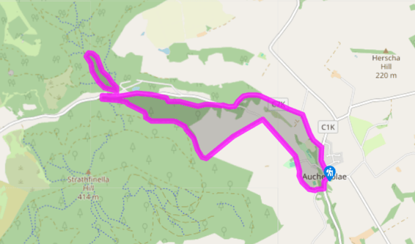
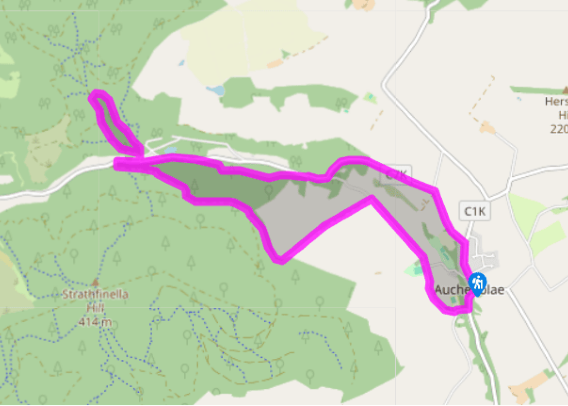
From the gap-site where the Drumtochty Hotel once stood (until destroyed by a gas explosion in 2009), walk down to the foot of the High Street. Go a short way down Kintore Street, cross a bridge over a stream and turn right, passing the village hall on your right. Take the next right to cross the Pamphil Burn, with the grounds of Auchenblae School on your right. On your left is Fordoun Parish Church – detour into the kirkyard to glimpse the remains of an ancient chapel and an even more ancient Pictish relic.
Soon after passing a cemetery on the left, turn left on a grassy track which runs through fields to reach the conifer plantation above. Pass a gate, and cross a patch of grass to reach a track (which may be thickly overgrown in summer).
Turn right and follow the track along the bottom edge of the forest. There are a couple of fallen trees to clamber over or walk around. At a wider gravel track, turn right and then continue, with fields still visible through the trees below. Above where these fields end, ignore a side-track up left. Soon after passing this, fork left on a fainter track.
The track runs level, then gently uphill. Where a pylon rises on the right-hand side of the track, strike downhill through the cleared ground under the electric wires – this may be awkward going, with brushwood underfoot.
At the bottom left corner of the cleared ground, a small path strikes left taking you into the forest. The path becomes clearer as it slants gradually down to join the valley road below. Turn sharp right along the road, passing a huge Sitka spruce tree (one of the largest in Britain), to Drumtochty car park on the left.
Take the track through the car park, bending up left past toilets. After a stiff climb on asphalt, turn right (red waymarker) down a zig-zag path to a mill lade. Turn left along this, to a footbridge above a weir. A little way upstream, the path climbs out of the steep valley, and contours upstream to pass above a small reservoir.
At the track beyond, turn left and return to Drumtochty car park. Turn left along the road until a path forks up right past a vehicle barrier. This leads to a forest track, which joins a larger one. Keep ahead, now level, until the track descends left to rejoin the road below.
Turn right and walk along the road to a junction. Turn left here, signed 'Auchenblae', and cross Pamphil Burn. At the following junction bear right, to reach the top end of Auchenblae's High Street.
'…you'd waken with the peewits crying across the hills, deep and deep, crying in the heart of you … almost you'd cry for that, the beauty of it and the sweetness of the Scottish land and skies.' Sunset Song, 1932 Those words were written by James Leslie Mitchell and sum up the immense love and... affection he had for his native Howe of the Mearns in northeast Scotland. It is fertile land, south of Aberdeen. This walk introduces you to this little-walked part of the country, an area that will forever be associated with the author. Mitchell is better known by his pen name of Lewis Grassic Gibbon. He was born in 1901 into a crofting family and had no illusions about the toughness of life on the land. He once wrote: 'My mother used to hap me in a plaid in harvest time and leave me in the lea of a stook while she harvested.' In his novels he portrayed the breakdown of crofting life, but did not gloss over its hardships. Crofter to author Gibbon became a journalist at the age of 16 and joined the Aberdeen Journal, and later the Scottish Farmer in Glasgow. He became ill and moved back home to work in the fields before joining the army as a clerk, later moving into the RAF. He travelled to Central America to see the remains of the Maya civilisation, and later claimed that his digestion was forever affected by the enforced local diet of maize. Gibbon left the forces in 1929 and returned to Britain, living in the south of England and trying to make his name as a writer. His first novel was Sunset Song, set in the Howe of the Mearns and telling the tale of Chris Guthrie, who was torn between her desire to escape her small community and her love for the land. He wrote it in six weeks. It was the first of a trilogy, known as A Scots Quair (or 'quire' – a volume), and was rapidly followed by the other books Cloud Howe (1933) and Grey Granite (1934). A short but prolific life Gibbon was extremely disciplined and driven – it was as if he knew he did not have much time to make his name. He divided each day into three and aimed to write 1,500 words in each session. He made some mistakes at first and tried to sell some of his short stories to the wrong type of magazines. However, H G Wells took an interest in his work and suggested different publications for him to try. Lewis Grassic Gibbon eventually died in 1935 of a duodenal ulcer. He was just 34, and had written 16 books.
Visitors to Aberdeenshire with any kind of interest in history are in for a treat. There are more castles to the acre in Aberdeenshire than anywhere else in Britain.
From the gap-site where the Drumtochty Hotel once stood (until destroyed by a gas explosion in 2009), walk down to the foot of the High Street. Go a short way down Kintore Street, cross a bridge over a stream and turn right, passing the village hall on your right. Take the next right to cross the Pamphil Burn, with the grounds of Auchenblae School on your right. On your left is Fordoun Parish Church – detour into the kirkyard to glimpse the remains of an ancient chapel and an even more ancient Pictish relic.
1 of 8
Soon after passing a cemetery on the left, turn left on a grassy track which runs through fields to reach the conifer plantation above. Pass a gate, and cross a patch of grass to reach a track (which may be thickly overgrown in summer).
2 of 8
Turn right and follow the track along the bottom edge of the forest. There are a couple of fallen trees to clamber over or walk around. At a wider gravel track, turn right and then continue, with fields still visible through the trees below. Above where these fields end, ignore a side-track up left. Soon after passing this, fork left on a fainter track.
3 of 8
The track runs level, then gently uphill. Where a pylon rises on the right-hand side of the track, strike downhill through the cleared ground under the electric wires – this may be awkward going, with brushwood underfoot.
4 of 8
At the bottom left corner of the cleared ground, a small path strikes left taking you into the forest. The path becomes clearer as it slants gradually down to join the valley road below. Turn sharp right along the road, passing a huge Sitka spruce tree (one of the largest in Britain), to Drumtochty car park on the left.
5 of 8
Take the track through the car park, bending up left past toilets. After a stiff climb on asphalt, turn right (red waymarker) down a zig-zag path to a mill lade. Turn left along this, to a footbridge above a weir. A little way upstream, the path climbs out of the steep valley, and contours upstream to pass above a small reservoir.
6 of 8
At the track beyond, turn left and return to Drumtochty car park. Turn left along the road until a path forks up right past a vehicle barrier. This leads to a forest track, which joins a larger one. Keep ahead, now level, until the track descends left to rejoin the road below.
7 of 8
Turn right and walk along the road to a junction. Turn left here, signed 'Auchenblae', and cross Pamphil Burn. At the following junction bear right, to reach the top end of Auchenblae's High Street.
'…you'd waken with the peewits crying across the hills, deep and deep, crying in the heart of you … almost you'd cry for that, the beauty of it and the sweetness of the Scottish land and skies.' Sunset Song, 1932 Those words were written by James Leslie Mitchell and sum up the immense love and... affection he had for his native Howe of the Mearns in northeast Scotland. It is fertile land, south of Aberdeen. This walk introduces you to this little-walked part of the country, an area that will forever be associated with the author. Mitchell is better known by his pen name of Lewis Grassic Gibbon. He was born in 1901 into a crofting family and had no illusions about the toughness of life on the land. He once wrote: 'My mother used to hap me in a plaid in harvest time and leave me in the lea of a stook while she harvested.' In his novels he portrayed the breakdown of crofting life, but did not gloss over its hardships. Crofter to author Gibbon became a journalist at the age of 16 and joined the Aberdeen Journal, and later the Scottish Farmer in Glasgow. He became ill and moved back home to work in the fields before joining the army as a clerk, later moving into the RAF. He travelled to Central America to see the remains of the Maya civilisation, and later claimed that his digestion was forever affected by the enforced local diet of maize. Gibbon left the forces in 1929 and returned to Britain, living in the south of England and trying to make his name as a writer. His first novel was Sunset Song, set in the Howe of the Mearns and telling the tale of Chris Guthrie, who was torn between her desire to escape her small community and her love for the land. He wrote it in six weeks. It was the first of a trilogy, known as A Scots Quair (or 'quire' – a volume), and was rapidly followed by the other books Cloud Howe (1933) and Grey Granite (1934). A short but prolific life Gibbon was extremely disciplined and driven – it was as if he knew he did not have much time to make his name. He divided each day into three and aimed to write 1,500 words in each session. He made some mistakes at first and tried to sell some of his short stories to the wrong type of magazines. However, H G Wells took an interest in his work and suggested different publications for him to try. Lewis Grassic Gibbon eventually died in 1935 of a duodenal ulcer. He was just 34, and had written 16 books.
Visitors to Aberdeenshire with any kind of interest in history are in for a treat. There are more castles to the acre in Aberdeenshire than anywhere else in Britain.