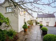
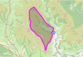
"Views of Crickhowell and the remote valleys of the central Black Mountains."
Walk directions
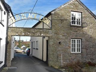
Walk back over the bridge and bear right up the ramp that leads to the second gate on the right. Cross the stile up some steps to the right of the gate and walk up the edge of a field to another stile that leads on to a lane. Cross this and climb over another stile to continue, with a wood on your left, up to yet another stile in a dry-stone wall.
Cross this and turn left to follow a faint path around the hillside through the bracken. Walk alongside the wall to a clear off-set crossroads, where the wall drops away, keep straight ahead here and at the next crossroads rejoin the wall shortly. Continue straight across another section where the wall drops away and then joins the path again.
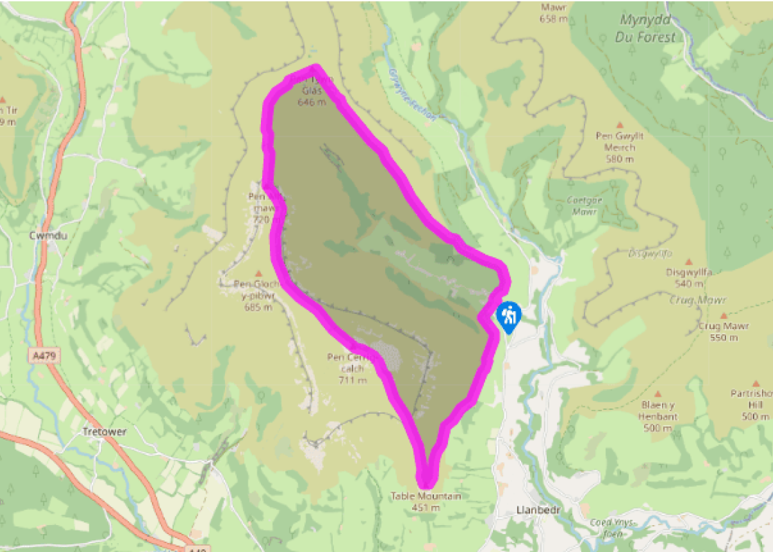
Next time it drops, keep straight ahead again to meet it at a pronounced corner of a field with two buildings at its foot. Turn right on to a clear track that leads straight up on to the summit of Table Mountain.
Turn off the plateau at its narrowest northern point and cross the saddle on an obvious track. This climbs steeply up on to Pen Cerrig-calch. As the path levels, ignore a track to the left and keep straight ahead until you reach the trig point.
Continue ahead to drop slightly down a small crag to meet the escarpment edge. Continue along the ridge, which narrows slightly, then climb again to the narrow summit of Pen Allt-mawr.
A path leads down the steep northern spur. Take this and cross flat, open and often wet ground towards a small hump ahead. As you start to climb, you’ll come to a parting of the paths.
Fork right here and continue to a small cairn on the top of a narrow ridge that leads southeast. Follow the ridge easily down until you eventually cross some quarried ground and come to a large cairn. Keep straight ahead to walk down to a stile marked ‘Footpath Only No Bikes’ at the top of a plantation. Cross this and keep straight ahead again to follow the rutted track alongside
two sides of the plantation. Where the third side drops away to the left carry straight on over a field, eventually meeting a wall to your right that takes you down to a track between walls where you pass through a gate.
Go downhill to a junction of paths. Keep straight ahead, through a gate, and head along the top of the field to a marker post that sends you left, downhill. Bear left at the bottom to a stile by a gate. This leads back to the lay-by.
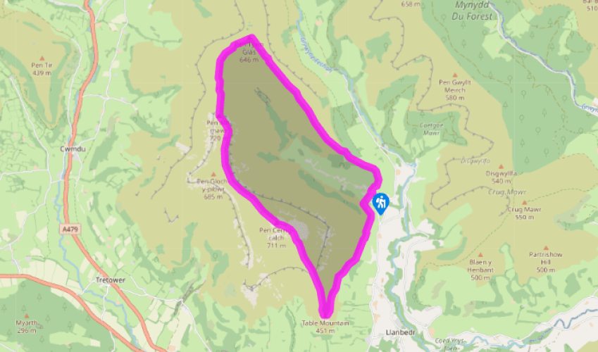
This walk climbs on to Table Mountain, which is topped with the remains of a most spectacularly positioned fortress. It then scales the steep escarpment above to cross Pen Cerrig-calch. Following a superb lofty traverse of another formidable peak, Pen Allt-mawr, the walk descends a broad ridge that... forms the western wall of the remote Grwyne Fechan valley. Towering above the mountain hub of Crickhowell, Table Mountain appears as a flat-topped knoll tucked beneath the white screes of Pen Cerrig-calch. It is topped by the ramparts of an impressive Iron Age fort known as Crug Hywel, which translates to ‘Hywel’s Fort.’ Hywel was a significant figure in Welsh history in the 10th century. The grandson of Rhodri the Great, who killed the leader of the Viking invaders at Anglesey, he made huge strides towards the unification of the infant nation and also gained much acclaim for the introduction of a system of rules, which became known as the Law of Wales. The rules, aimed at freeing the common man from the scruples of rich and powerful merchants, gave improved rights to women as well as placing values on everyday items such as domestic cats. He became known as Hywel Dda, or Hywel the Good. Although Hywel reigned in the 10th century, the fortifications on the hilltop are probably 1,000 years older. He may have taken advantage of the naturally defended position at some stage. Standing guard over Crug Hywel is the 2,300ft (701m) peak of Pen Cerrigcalch. It is unique as the highest limestone peak in a landscape that comprises mainly old red sandstone. The name says it all; cerrig is stone and calch is lime. Although it appears now to be an isolated pocket of the soft white rock, it would have once been linked to the larger tract south of the Usk.
The largest unitary authority in Wales, Powys covers an area of approximately 2,000 square miles. Much of that is mountainous because it actually has the lowest population density of all the Welsh counties.
"Views of Crickhowell and the remote valleys of the central Black Mountains."
Walk details
4hrs 30min
Difficulty:
Hard
Gradient:
Challenging
Distance:
8.5 miles (13.7kms)
Ascent:
1700ft (518m)
Walk directions
Walk back over the bridge and bear right up the ramp that leads to the second gate on the right. Cross the stile up some steps to the right of the gate and walk up the edge of a field to another stile that leads on to a lane. Cross this and climb over another stile to continue, with a wood on your left, up to yet another stile in a dry-stone wall.
1 of 8
Cross this and turn left to follow a faint path around the hillside through the bracken. Walk alongside the wall to a clear off-set crossroads, where the wall drops away, keep straight ahead here and at the next crossroads rejoin the wall shortly. Continue straight across another section where the wall drops away and then joins the path again.
2 of 8
Next time it drops, keep straight ahead again to meet it at a pronounced corner of a field with two buildings at its foot. Turn right on to a clear track that leads straight up on to the summit of Table Mountain.
3 of 8
Turn off the plateau at its narrowest northern point and cross the saddle on an obvious track. This climbs steeply up on to Pen Cerrig-calch. As the path levels, ignore a track to the left and keep straight ahead until you reach the trig point.
4 of 8
Continue ahead to drop slightly down a small crag to meet the escarpment edge. Continue along the ridge, which narrows slightly, then climb again to the narrow summit of Pen Allt-mawr.
5 of 8
A path leads down the steep northern spur. Take this and cross flat, open and often wet ground towards a small hump ahead. As you start to climb, you’ll come to a parting of the paths.
6 of 8
Fork right here and continue to a small cairn on the top of a narrow ridge that leads southeast. Follow the ridge easily down until you eventually cross some quarried ground and come to a large cairn. Keep straight ahead to walk down to a stile marked ‘Footpath Only No Bikes’ at the top of a plantation. Cross this and keep straight ahead again to follow the rutted track alongside
two sides of the plantation. Where the third side drops away to the left carry straight on over a field, eventually meeting a wall to your right that takes you down to a track between walls where you pass through a gate.
7 of 8
Go downhill to a junction of paths. Keep straight ahead, through a gate, and head along the top of the field to a marker post that sends you left, downhill. Bear left at the bottom to a stile by a gate. This leads back to the lay-by.
This walk climbs on to Table Mountain, which is topped with the remains of a most spectacularly positioned fortress. It then scales the steep escarpment above to cross Pen Cerrig-calch. Following a superb lofty traverse of another formidable peak, Pen Allt-mawr, the walk descends a broad ridge that... forms the western wall of the remote Grwyne Fechan valley. Towering above the mountain hub of Crickhowell, Table Mountain appears as a flat-topped knoll tucked beneath the white screes of Pen Cerrig-calch. It is topped by the ramparts of an impressive Iron Age fort known as Crug Hywel, which translates to ‘Hywel’s Fort.’ Hywel was a significant figure in Welsh history in the 10th century. The grandson of Rhodri the Great, who killed the leader of the Viking invaders at Anglesey, he made huge strides towards the unification of the infant nation and also gained much acclaim for the introduction of a system of rules, which became known as the Law of Wales. The rules, aimed at freeing the common man from the scruples of rich and powerful merchants, gave improved rights to women as well as placing values on everyday items such as domestic cats. He became known as Hywel Dda, or Hywel the Good. Although Hywel reigned in the 10th century, the fortifications on the hilltop are probably 1,000 years older. He may have taken advantage of the naturally defended position at some stage. Standing guard over Crug Hywel is the 2,300ft (701m) peak of Pen Cerrigcalch. It is unique as the highest limestone peak in a landscape that comprises mainly old red sandstone. The name says it all; cerrig is stone and calch is lime. Although it appears now to be an isolated pocket of the soft white rock, it would have once been linked to the larger tract south of the Usk.
The largest unitary authority in Wales, Powys covers an area of approximately 2,000 square miles. Much of that is mountainous because it actually has the lowest population density of all the Welsh counties.