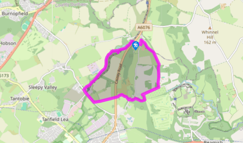
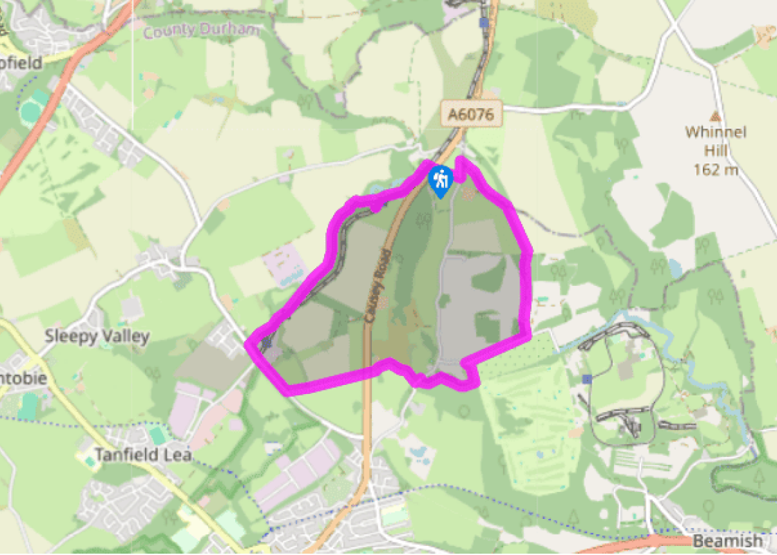
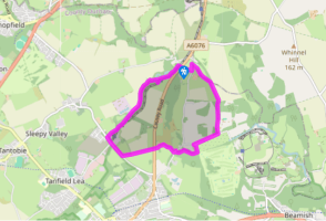
Leave the car park through the ‘Exit’ archway. Cross the road and take a signed footpath just left of the bus stop. Cross a stile and head up the field edge, leaving at the top corner onto a lane.
Go left towards the Causey Arch Inn. However, after 100yds (91m) turn off right up a track signed as a footpath. As it swings right keep ahead on a narrow path, shortly joining a farm track. Walk on for 150yds (137m) then fork right along a grass path.
Passing a barrier at the end turn right, descending through woodland to emerge past houses onto a lane. Go right for 0.25 miles (400m) to the former Beamishburn Picnic Area. Turn in beside the barrier, following the drive past the car park to a footbridge.
Over the bridge, turn right beside the burn. Keep right at a fork, but then, just before a side stream, turn left up a stepped path. At a crossing, go right, shortly emerging onto a lane. Walk left to then take a track off right beside a sign for Mole Hill Farm.
Eventually approaching a gate, turn left and follow the boundary behind farm buildings to a stile. Climb right up a grass bank, crossing another stile to drop to the main road.
Cross to a footpath opposite, which rises left before swinging right to run fenced beside a field. Part way down a second field, slip through the hedge to continue down its opposite flank. Emerging at the bottom onto another busy road, go right, passing a road off left before reaching the entrance to the Tanfield Railway.
Turn in and keep ahead through a gap by a bench at the top. Continue along the valley, ignoring a bridge before rising above the deepening gorge. Eventually climb steps to a higher path and keep right to the Causey Arch.
Over the bridge is a replica wagon, while to the right, there's a fine viewpoint. The quick return lies back past the wagon along a path beside the railway. Otherwise re-cross the arch and drop right on a stepped path into the gorge. Walk left beside the burn, winding over a footbridge. Continue downstream, crossing two more bridges. Approaching a fourth bridge, turn off right, climbing steps onto the high embankment. Joining the main path, go left back to the car park.
When the Tanfield Railway was built in 1725 it was reckoned to be the largest civil engineering project since Roman times. It was paid for by a group of local landowners with collieries on their estates – they called themselves the ‘Grand Allies’. During the walk you will see some of the enormous... earthwork embankments the navvies constructed for the horse-drawn wagons that took coal from the local collieries to wharfs on the River Tyne. Steam trains now run on part of the line, from East Tanfield to Sunniside, with a stop at Causey Arch. Near by is the world’s oldest surviving engine shed, built in 1854, where some of the railway’s 40 locomotives and carriages can be seen. Memories of Beamish The first part of the walk will take you away from the railway towards Beamish Hall, a former home of the Shaftoe family – one of their number, Bobby Shaftoe, attained fame in a nursery song. The house was once the headquarters of the National Coal Board, and later an adult education college. It is now a hotel and used for weddings and conferences. Further along the walk, look out by Beamish Burn for the ghost of a grey lady, said to have been an inhabitant of the hall who hid herself in a trunk to avoid a marriage she did not want, and suffocated. This part of the route follows the Great North Forest Trail, a 65-mile (105km) route from Causey Arch to Marsden Bay near South Shields, which was established as part of an initiative to regenerate urban fringe countryside in the area. On the old track From East Tanfield you will follow one of several waggonways that led to Causey Arch. Horses pulled wagons holding four tons of coal along this route above the increasingly steep slopes of the Causey Gill gorge – in many places embankments had to be built to ensure a level route for the wooden rails. Today it is a peaceful path but in its short heyday, from 1725 to the 1740s, the track saw hundreds of wagons, each only 50yds (46m) apart, carry their loads of coal towards the bridge. The oldest arch Causey Arch is claimed to be the oldest railway bridge in the world. It was built by a local stonemason, Ralph Wood, for the Grand Allies, and at the time it was the largest single-span bridge, 105ft (32m) long and 80ft (24.4m) high. Wood relied on the same building techniques that the Romans used 16 centuries before. After railway activity stopped, the bridge quietly mouldered for almost 200 years until it was restored by Durham County Council in the 1980s. Below the bridge you can see where the Causey Burn was diverted through culverts to enable embankments to be constructed.
The metropolitan county of Tyne and Wear encompasses Newcastle-upon-Tyne, Gateshead, South Shields and Sunderland, as well as part of Hadrian’s Wall. The county is cut through by the two rivers after which it is named.
Leave the car park through the ‘Exit’ archway. Cross the road and take a signed footpath just left of the bus stop. Cross a stile and head up the field edge, leaving at the top corner onto a lane.
1 of 8
Go left towards the Causey Arch Inn. However, after 100yds (91m) turn off right up a track signed as a footpath. As it swings right keep ahead on a narrow path, shortly joining a farm track. Walk on for 150yds (137m) then fork right along a grass path.
2 of 8
Passing a barrier at the end turn right, descending through woodland to emerge past houses onto a lane. Go right for 0.25 miles (400m) to the former Beamishburn Picnic Area. Turn in beside the barrier, following the drive past the car park to a footbridge.
3 of 8
Over the bridge, turn right beside the burn. Keep right at a fork, but then, just before a side stream, turn left up a stepped path. At a crossing, go right, shortly emerging onto a lane. Walk left to then take a track off right beside a sign for Mole Hill Farm.
4 of 8
Eventually approaching a gate, turn left and follow the boundary behind farm buildings to a stile. Climb right up a grass bank, crossing another stile to drop to the main road.
5 of 8
Cross to a footpath opposite, which rises left before swinging right to run fenced beside a field. Part way down a second field, slip through the hedge to continue down its opposite flank. Emerging at the bottom onto another busy road, go right, passing a road off left before reaching the entrance to the Tanfield Railway.
6 of 8
Turn in and keep ahead through a gap by a bench at the top. Continue along the valley, ignoring a bridge before rising above the deepening gorge. Eventually climb steps to a higher path and keep right to the Causey Arch.
7 of 8
Over the bridge is a replica wagon, while to the right, there's a fine viewpoint. The quick return lies back past the wagon along a path beside the railway. Otherwise re-cross the arch and drop right on a stepped path into the gorge. Walk left beside the burn, winding over a footbridge. Continue downstream, crossing two more bridges. Approaching a fourth bridge, turn off right, climbing steps onto the high embankment. Joining the main path, go left back to the car park.
When the Tanfield Railway was built in 1725 it was reckoned to be the largest civil engineering project since Roman times. It was paid for by a group of local landowners with collieries on their estates – they called themselves the ‘Grand Allies’. During the walk you will see some of the enormous... earthwork embankments the navvies constructed for the horse-drawn wagons that took coal from the local collieries to wharfs on the River Tyne. Steam trains now run on part of the line, from East Tanfield to Sunniside, with a stop at Causey Arch. Near by is the world’s oldest surviving engine shed, built in 1854, where some of the railway’s 40 locomotives and carriages can be seen. Memories of Beamish The first part of the walk will take you away from the railway towards Beamish Hall, a former home of the Shaftoe family – one of their number, Bobby Shaftoe, attained fame in a nursery song. The house was once the headquarters of the National Coal Board, and later an adult education college. It is now a hotel and used for weddings and conferences. Further along the walk, look out by Beamish Burn for the ghost of a grey lady, said to have been an inhabitant of the hall who hid herself in a trunk to avoid a marriage she did not want, and suffocated. This part of the route follows the Great North Forest Trail, a 65-mile (105km) route from Causey Arch to Marsden Bay near South Shields, which was established as part of an initiative to regenerate urban fringe countryside in the area. On the old track From East Tanfield you will follow one of several waggonways that led to Causey Arch. Horses pulled wagons holding four tons of coal along this route above the increasingly steep slopes of the Causey Gill gorge – in many places embankments had to be built to ensure a level route for the wooden rails. Today it is a peaceful path but in its short heyday, from 1725 to the 1740s, the track saw hundreds of wagons, each only 50yds (46m) apart, carry their loads of coal towards the bridge. The oldest arch Causey Arch is claimed to be the oldest railway bridge in the world. It was built by a local stonemason, Ralph Wood, for the Grand Allies, and at the time it was the largest single-span bridge, 105ft (32m) long and 80ft (24.4m) high. Wood relied on the same building techniques that the Romans used 16 centuries before. After railway activity stopped, the bridge quietly mouldered for almost 200 years until it was restored by Durham County Council in the 1980s. Below the bridge you can see where the Causey Burn was diverted through culverts to enable embankments to be constructed.
The metropolitan county of Tyne and Wear encompasses Newcastle-upon-Tyne, Gateshead, South Shields and Sunderland, as well as part of Hadrian’s Wall. The county is cut through by the two rivers after which it is named.