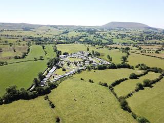
"A gallon in a quart pot - the diversity of Arnside-Silverdale in one shot"
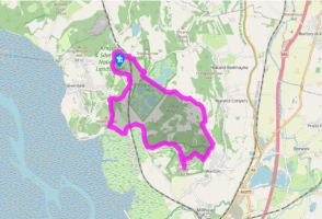
Walk directions
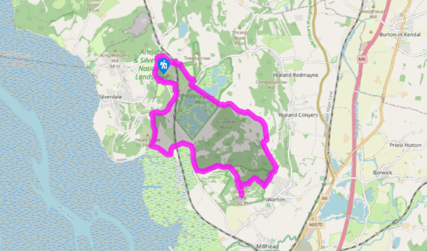
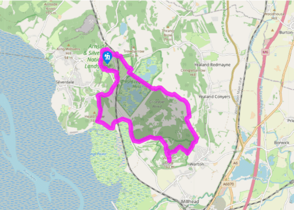
Follow the lane opposite the car park. Descending to the main road, go right and keep right at the next junction. Over the brow turn left into Hollins Lane. After 150yds (137m), turn off left on a track towards Brown's Point and the shore. Leaving the wood, skirt Heald Brow to a flood embankment.
Go left over a stile, following the causeway towards Quaker's Stang. At the end, swing right and left, passing beneath the railway to the road.
Walk right. Rounding a bend, fork left up Crag Lane. At the crest, turn left onto a bridleway. Climb for almost 0.75 miles (1.2km), passing a gate and stile to a second gate on the right at the top of the rise.
Through that, walk to an information board and fork left, climbing gently to a kissing gate. Keep going towards more trees and a signposted junction. Turn right to the beacon, walking just beyond for a stunning view.
Return to the signpost and take the right branch, descending to another fork by a split boulder. Go right, dropping more steeply. Through a short gully, keep with the main path, later forking left through another rocky trough. Approaching a wall, go left and then keep right where the path later forks, emerging onto a track. Turn right to a lane.
Walk left along for 0.75 miles (1.2km), passing Leighton Hall's entrance. At the crest of the hill, turn off through a gate on the left and follow a woodland path towards Summerhouse Viewpoint. Leaving the wood, carry on within a belt of trees, shortly meeting a crossing path. Go left past a bench and continue downhill towards Leighton Hall.
Joining the main drive, turn right and keep right past the hall entrance. At a junction beyond Grisedale cottage and farm, swing right. Pass through a gate to follow a track across Leighton Moss.
Emerging onto a lane, go right, leaving after 100yds (91m) through a gate on the left. Head directly away to a gate at the edge of the golf course. Bear right across the fairway then carry on beside rough to a tall post marking a stile in the corner. Bear left over a second fairway to another stile. Walk forward over a crossing track, curving left along a wooded trough to re-meet the track by an information board. Keep ahead again to a stile at the wood's perimeter and carefully cross the railway. Climb right to a lane and go left. Turn right along the main road, bearing left at the next junction back to the car park.
Warton Crag, a great mass of limestone, is the highest point of the Arnside and Silverdale AONB, its relative isolation making it a superb vantage. The view extends over the Keer estuary across Morecambe Bay, sweeping around to the mountains of Cumbria. Inland is the western fringe of the Bowland... Fells, while further north are the highlands of the Yorkshire Dales. Early settlement Traces of settlement from the Stone Age have been discovered and the summit is the site of an Iron Age fort, established by the Brigantes and occupied into the Roman era. More lately the hilltop was a beacon post, part of a chain to warn of an impending Spanish invasion, the present beacon being a replica erected for a re-enactment on the 400th anniversary of the Armada. Wildlife habitat In the past, the hill was grazed extensively by goats and sheep, there was even a local breed, and nibbling rabbits were everywhere. Consequently, much of the hill was open grassland, while the remaining woodland was managed by coppicing and felling. But the sheep were taken off in the 1940s and the rabbit population decimated by myxomatosis in the mid-1950s. Since then the tree cover has flourished and both cattle and sheep have been reintroduced alongside woodland management to preserve the hill's habitat diversity. It is a particularly important site for butterflies, including the endangered high brown fritillary, whose caterpillars feed on the leaves of violets. The southern face of the hill was extensively quarried until 1966, when it supplied materials for the M6 motorway. The cliffs are now popular both with climbers and peregrines, which breed there. Leighton Moss The return lies along a causeway through the Leighton Moss bird reserve. During the 19th century, the area was drained, creating land that was so fertile that it became known as the Golden Vale. But during World War I, fuel for the drainage pump was in short supply and the land reverted to pools and reed beds. Since 1964 it has been managed by the RSPB and now attracts a huge variety of both visiting and resident birds. A great success has been the establishment of breeding bittern, whose call is more likely to be heard than a glimpse of the bird.
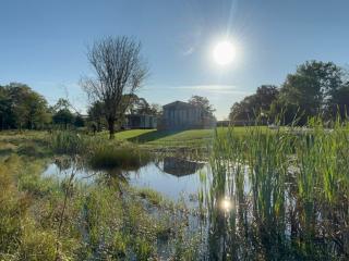
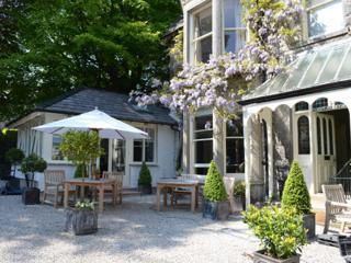
Cumbria's rugged yet beautiful landscape is best known for the Lake District National Park that sits within its boundaries. It’s famous for Lake Windermere, England’s largest lake, and Derwent Water, ‘Queen of the English Lakes', but other lesser-known areas in the south, such as the Lune Valley and the coastal towns, are secret gems of wide cobbled streets and rolling hills.
"A gallon in a quart pot - the diversity of Arnside-Silverdale in one shot"
Walk details
3hrs
Difficulty:
Medium
Gradient:
Moderate
Distance:
7.75 miles (12.5kms)
Ascent:
985ft (300m)
Walk directions
Follow the lane opposite the car park. Descending to the main road, go right and keep right at the next junction. Over the brow turn left into Hollins Lane. After 150yds (137m), turn off left on a track towards Brown's Point and the shore. Leaving the wood, skirt Heald Brow to a flood embankment.
1 of 8
Go left over a stile, following the causeway towards Quaker's Stang. At the end, swing right and left, passing beneath the railway to the road.
2 of 8
Walk right. Rounding a bend, fork left up Crag Lane. At the crest, turn left onto a bridleway. Climb for almost 0.75 miles (1.2km), passing a gate and stile to a second gate on the right at the top of the rise.
3 of 8
Through that, walk to an information board and fork left, climbing gently to a kissing gate. Keep going towards more trees and a signposted junction. Turn right to the beacon, walking just beyond for a stunning view.
4 of 8
Return to the signpost and take the right branch, descending to another fork by a split boulder. Go right, dropping more steeply. Through a short gully, keep with the main path, later forking left through another rocky trough. Approaching a wall, go left and then keep right where the path later forks, emerging onto a track. Turn right to a lane.
5 of 8
Walk left along for 0.75 miles (1.2km), passing Leighton Hall's entrance. At the crest of the hill, turn off through a gate on the left and follow a woodland path towards Summerhouse Viewpoint. Leaving the wood, carry on within a belt of trees, shortly meeting a crossing path. Go left past a bench and continue downhill towards Leighton Hall.
6 of 8
Joining the main drive, turn right and keep right past the hall entrance. At a junction beyond Grisedale cottage and farm, swing right. Pass through a gate to follow a track across Leighton Moss.
7 of 8
Emerging onto a lane, go right, leaving after 100yds (91m) through a gate on the left. Head directly away to a gate at the edge of the golf course. Bear right across the fairway then carry on beside rough to a tall post marking a stile in the corner. Bear left over a second fairway to another stile. Walk forward over a crossing track, curving left along a wooded trough to re-meet the track by an information board. Keep ahead again to a stile at the wood's perimeter and carefully cross the railway. Climb right to a lane and go left. Turn right along the main road, bearing left at the next junction back to the car park.
Warton Crag, a great mass of limestone, is the highest point of the Arnside and Silverdale AONB, its relative isolation making it a superb vantage. The view extends over the Keer estuary across Morecambe Bay, sweeping around to the mountains of Cumbria. Inland is the western fringe of the Bowland... Fells, while further north are the highlands of the Yorkshire Dales. Early settlement Traces of settlement from the Stone Age have been discovered and the summit is the site of an Iron Age fort, established by the Brigantes and occupied into the Roman era. More lately the hilltop was a beacon post, part of a chain to warn of an impending Spanish invasion, the present beacon being a replica erected for a re-enactment on the 400th anniversary of the Armada. Wildlife habitat In the past, the hill was grazed extensively by goats and sheep, there was even a local breed, and nibbling rabbits were everywhere. Consequently, much of the hill was open grassland, while the remaining woodland was managed by coppicing and felling. But the sheep were taken off in the 1940s and the rabbit population decimated by myxomatosis in the mid-1950s. Since then the tree cover has flourished and both cattle and sheep have been reintroduced alongside woodland management to preserve the hill's habitat diversity. It is a particularly important site for butterflies, including the endangered high brown fritillary, whose caterpillars feed on the leaves of violets. The southern face of the hill was extensively quarried until 1966, when it supplied materials for the M6 motorway. The cliffs are now popular both with climbers and peregrines, which breed there. Leighton Moss The return lies along a causeway through the Leighton Moss bird reserve. During the 19th century, the area was drained, creating land that was so fertile that it became known as the Golden Vale. But during World War I, fuel for the drainage pump was in short supply and the land reverted to pools and reed beds. Since 1964 it has been managed by the RSPB and now attracts a huge variety of both visiting and resident birds. A great success has been the establishment of breeding bittern, whose call is more likely to be heard than a glimpse of the bird.
Cumbria's rugged yet beautiful landscape is best known for the Lake District National Park that sits within its boundaries. It’s famous for Lake Windermere, England’s largest lake, and Derwent Water, ‘Queen of the English Lakes', but other lesser-known areas in the south, such as the Lune Valley and the coastal towns, are secret gems of wide cobbled streets and rolling hills.