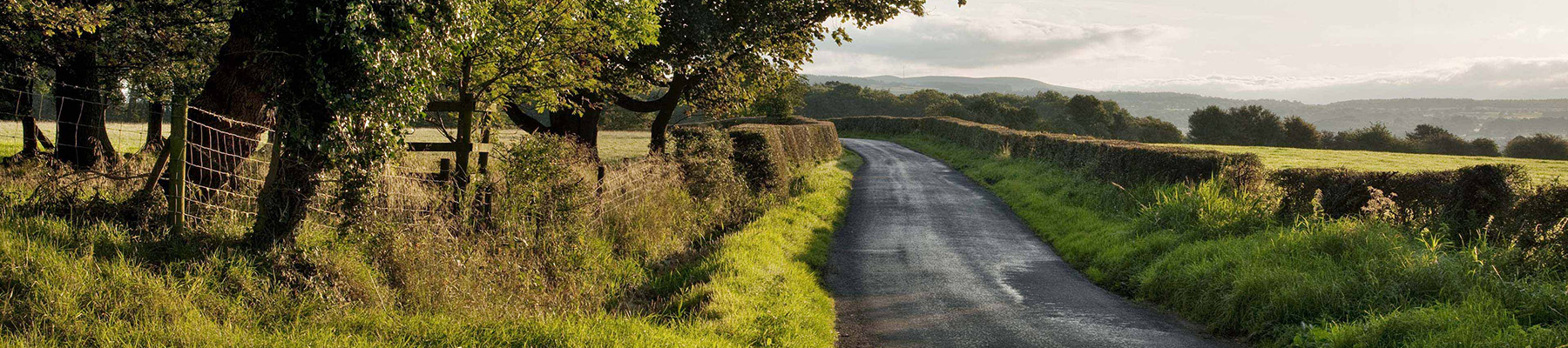
"Partly a town trail, but mostly a rural walk beside the River Ribble."
Walk directions
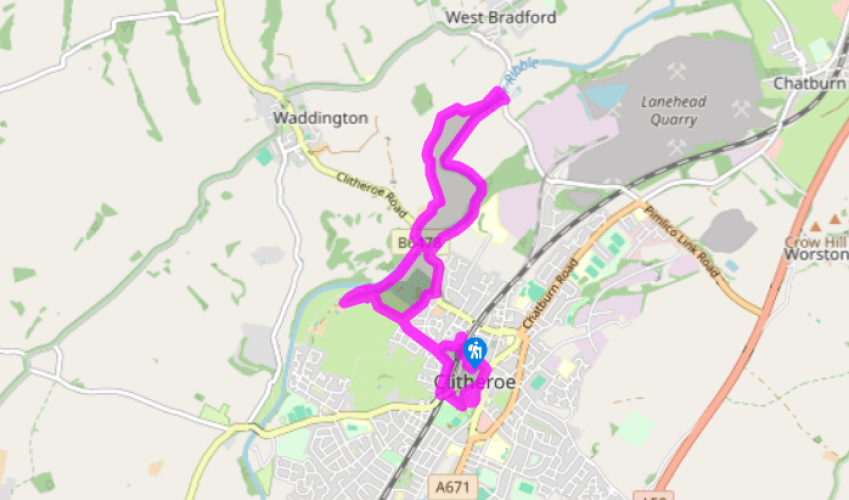
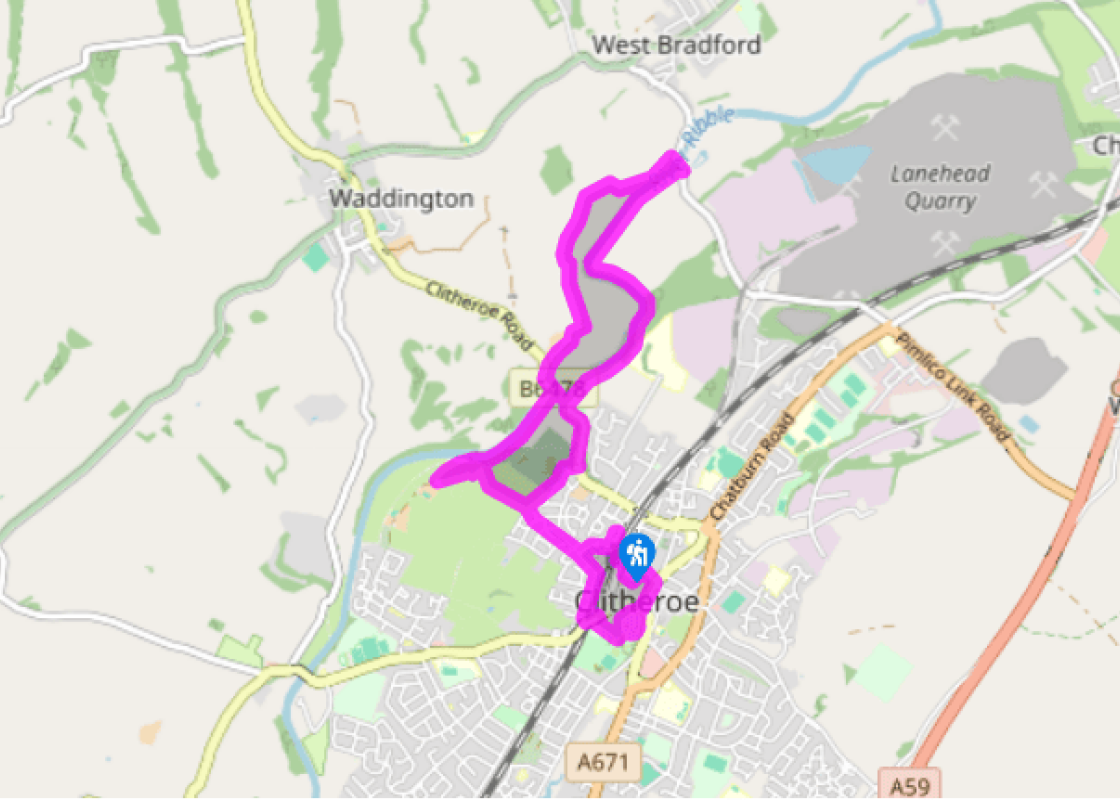
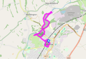
Out of the car park, turn right, continuing past bollards into Kirkmoor Road. At the corner, go right along Back Commons, leaving as it swings left, through a kissing gate on the right. Head across grazing, bearing right in the next field to a gate. Immediately turn right through a second gate and follow the right boundary. Continue beside the cemetery, joining its drive to the road. Head downhill.
Leave beyond the bend through the second entrance to Brungerley Park on the right. Take the right branch when the path forks, but watch for a stepped path later dropping to the riverbank. Entering Cross Hill Nature Reserve, walk past the quarry. Reaching a fork by a sculpted otter, branch left. Exiting the wood, continue by riverside pasture, eventually meeting a lane.
Cross Bradford Bridge and immediately leave through a gap on the left to head downstream. Eventually forced upfield by a hedge, bear right partway along the second field to pass through a small copse in the top corner. Emerging beyond, cross the bottom of two fields then strike half left across a larger expanse to a field-bridge. Continue across a smaller enclosure to the far-left corner and then swing left to cross Waddington Brook. Head upfield to a gate and continue on a track by the right hedge. Leaving the field, swing right and walk below Brungerley Farm to a road.
Turn downhill to cross Brungerley Bridge, then leave over a stile on the right by a bus shelter. Follow the riverbank into Boy Bank Wood, but, approaching the foot of steps, bear right past a weir and alongside its leat.
Rising onto a bank, double back to a waymarked junction above the stepped path from the wood. Bear off right (not sharp right) to a kissing gate at the corner of trees and walk on by the left hedge. In the corner, go through the kissing gate ahead and reverse your outward route over the fields and along Back Commons to the corner of Kirkmoor Road.
This time, however, keep ahead to the end and there go right along Castle View. Reaching the main road, turn left over the railway. At the end of the right-hand parapet, double back sharp right beneath a footbridge serving the Methodist chapel. Entering a park swing left on a rising drive and take the second left towards the top. Skirt beneath the castle then bear right up to the entrance.
Leaving the castle, return down the drive and bear right to exit the main gate. Continue ahead down Castle Street to the White Lion and swing left through an archway beside it. Walk past car parking to emerge onto Railway View Avenue. Go left to King Street and there turn right to the station. At the bottom, go right and then first left beneath a bridge back to Chester Avenue and the car park.
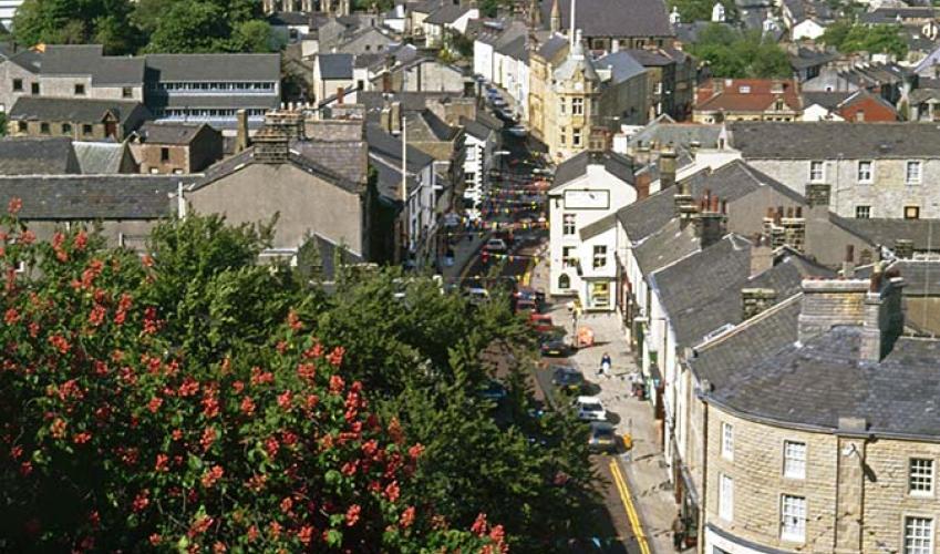
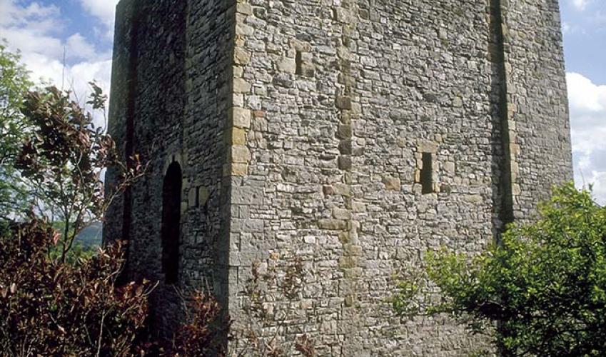
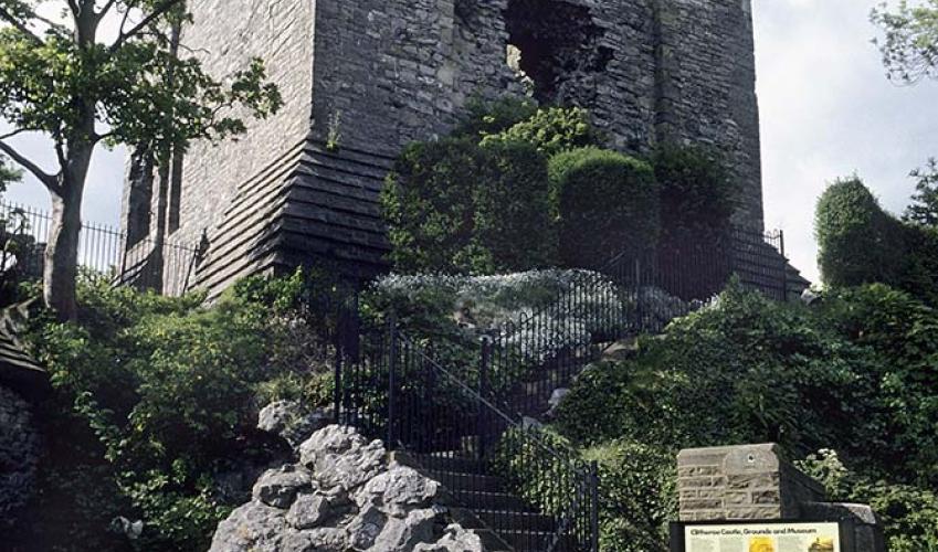
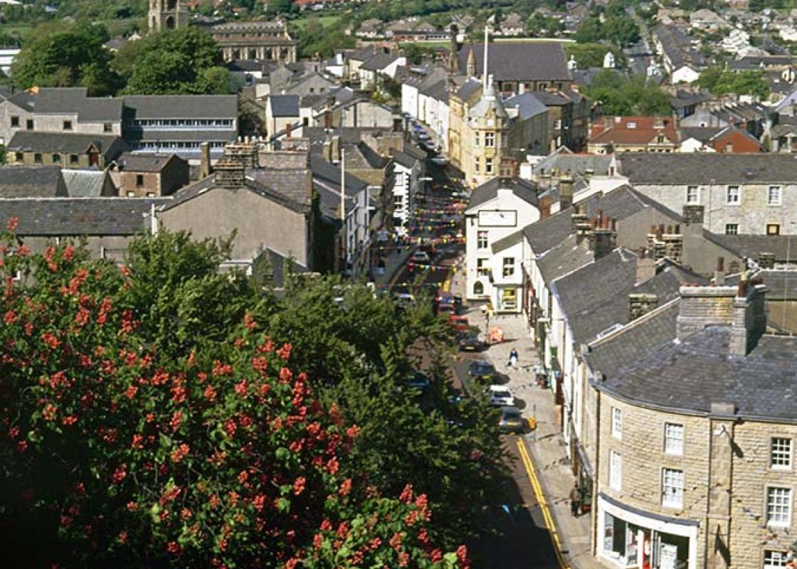
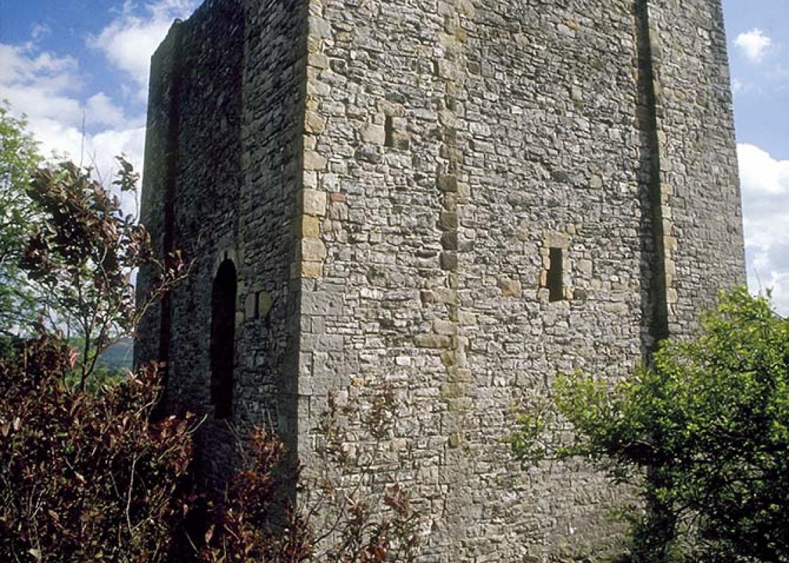
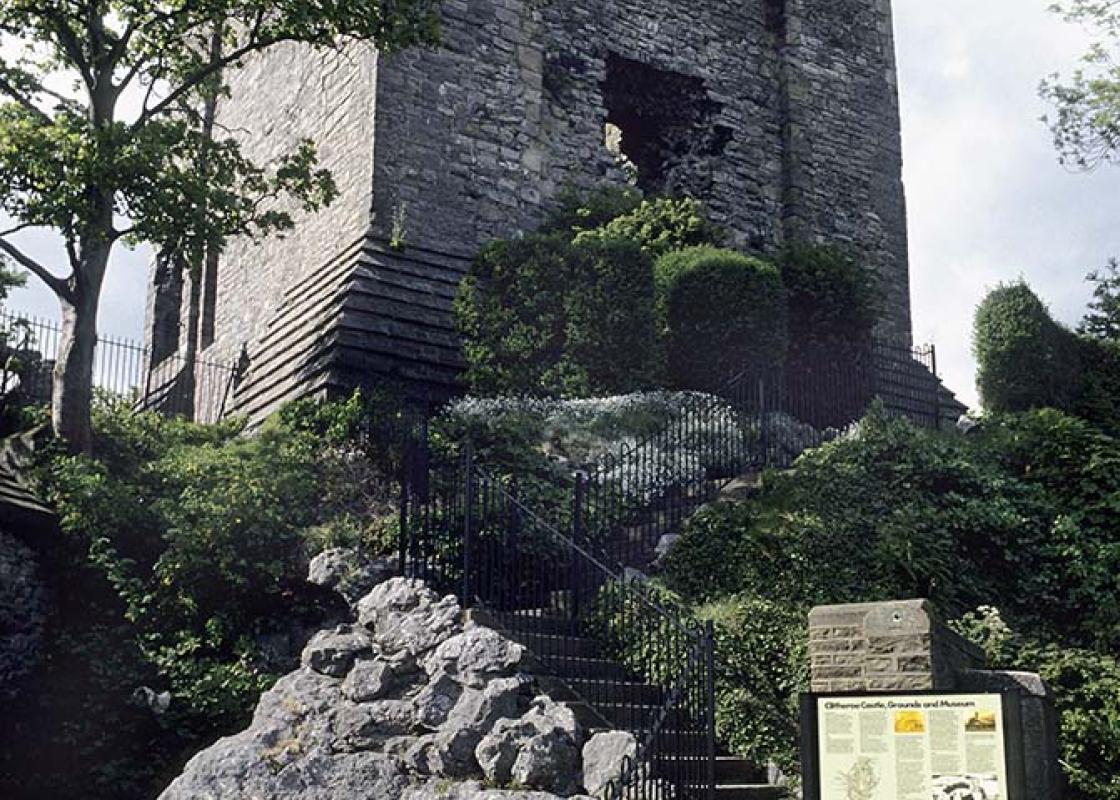
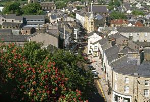
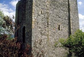
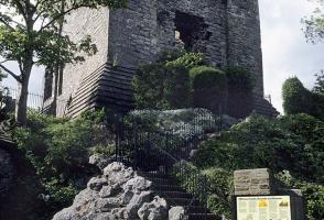
Clitheroe is draped along a ridge of limestone overlooking the River Ribble, part of an undersea mound that formed around 340 million years ago. The stone has been quarried around the town for the last 400 years, being burnt to produce quicklime and cement in an industry that continues to this day.... But abandoned quarries can provide special habitats for wild flowers and insects, such as the Cross Hill Quarry, passed on the outward leg of the walk. An ancient castle A tiny Norman castle, said to be one of the smallest in England, rises on a prominent rocky spur at the heart of the town and is one of the oldest buildings in the county. Legend has it that the great void in its side was the work of the Devil, who tossed a boulder at it from the top of Pendle Hill. As usual, reality is less colourful, the castle had been briefly held for the King during the Civil War and although subsequently abandoned, the Parliamentarians slighted the walls to prevent its use again as a stronghold. Today, the castle contains a museum. Among its many artefacts is the last boat to be used at Hacking Ferry; the service finished in 1955, and although several plans have been proposed for a replacement footbridge across the Ribble, none has materialised. There is also a small hoard of silver coins found at Mitton, which date to the reign of Henry VI. The Lancastrian king passed through the area following his army's defeat at the Battle of Hexham in 1646. He was sheltered for a time by Sir Ralph Pudsey at nearby Bolton by Bowland, but then came to Waddington. His presence was betrayed to the Yorkists and, although he managed to escape across the Ribble at Brungerley (there was no bridge then, only stepping stones), he was soon captured. After spending the night in Clitheroe Castle, he was taken to London and left to languish in the Tower. Local delicacies Today, Clitheroe is locally noted for its sausages. Cowman's Famous Sausage Shop (now run by the Cowburn's) has been at the top of Castle Street for more than 120 years and produces over 70 different varieties of sausage, ranging from traditional pork, perhaps mixed with black pudding or apple and mint, to more exotic creations such as Moroccan lamb or Thai pork. Just along the road at Chatburn, you will find another delicacy in Hudson's ice cream shop. They've been there for over a century, making delicious home-made ices to an old family recipe.
Lancashire was at the centre of the British cotton industry in the 19th century, which lead to the urbanization of great tracts of the area. The cotton boom came and went, but the industrial profile remains.
"Partly a town trail, but mostly a rural walk beside the River Ribble."
Walk details
1hr 45min
Difficulty:
Easy
Gradient:
Gentle
Distance:
5 miles (8kms)
Ascent:
320ft (98m)
Walk directions
Out of the car park, turn right, continuing past bollards into Kirkmoor Road. At the corner, go right along Back Commons, leaving as it swings left, through a kissing gate on the right. Head across grazing, bearing right in the next field to a gate. Immediately turn right through a second gate and follow the right boundary. Continue beside the cemetery, joining its drive to the road. Head downhill.
1 of 7
Leave beyond the bend through the second entrance to Brungerley Park on the right. Take the right branch when the path forks, but watch for a stepped path later dropping to the riverbank. Entering Cross Hill Nature Reserve, walk past the quarry. Reaching a fork by a sculpted otter, branch left. Exiting the wood, continue by riverside pasture, eventually meeting a lane.
2 of 7
Cross Bradford Bridge and immediately leave through a gap on the left to head downstream. Eventually forced upfield by a hedge, bear right partway along the second field to pass through a small copse in the top corner. Emerging beyond, cross the bottom of two fields then strike half left across a larger expanse to a field-bridge. Continue across a smaller enclosure to the far-left corner and then swing left to cross Waddington Brook. Head upfield to a gate and continue on a track by the right hedge. Leaving the field, swing right and walk below Brungerley Farm to a road.
3 of 7
Turn downhill to cross Brungerley Bridge, then leave over a stile on the right by a bus shelter. Follow the riverbank into Boy Bank Wood, but, approaching the foot of steps, bear right past a weir and alongside its leat.
4 of 7
Rising onto a bank, double back to a waymarked junction above the stepped path from the wood. Bear off right (not sharp right) to a kissing gate at the corner of trees and walk on by the left hedge. In the corner, go through the kissing gate ahead and reverse your outward route over the fields and along Back Commons to the corner of Kirkmoor Road.
5 of 7
This time, however, keep ahead to the end and there go right along Castle View. Reaching the main road, turn left over the railway. At the end of the right-hand parapet, double back sharp right beneath a footbridge serving the Methodist chapel. Entering a park swing left on a rising drive and take the second left towards the top. Skirt beneath the castle then bear right up to the entrance.
6 of 7
Leaving the castle, return down the drive and bear right to exit the main gate. Continue ahead down Castle Street to the White Lion and swing left through an archway beside it. Walk past car parking to emerge onto Railway View Avenue. Go left to King Street and there turn right to the station. At the bottom, go right and then first left beneath a bridge back to Chester Avenue and the car park.
Clitheroe is draped along a ridge of limestone overlooking the River Ribble, part of an undersea mound that formed around 340 million years ago. The stone has been quarried around the town for the last 400 years, being burnt to produce quicklime and cement in an industry that continues to this day.... But abandoned quarries can provide special habitats for wild flowers and insects, such as the Cross Hill Quarry, passed on the outward leg of the walk. An ancient castle A tiny Norman castle, said to be one of the smallest in England, rises on a prominent rocky spur at the heart of the town and is one of the oldest buildings in the county. Legend has it that the great void in its side was the work of the Devil, who tossed a boulder at it from the top of Pendle Hill. As usual, reality is less colourful, the castle had been briefly held for the King during the Civil War and although subsequently abandoned, the Parliamentarians slighted the walls to prevent its use again as a stronghold. Today, the castle contains a museum. Among its many artefacts is the last boat to be used at Hacking Ferry; the service finished in 1955, and although several plans have been proposed for a replacement footbridge across the Ribble, none has materialised. There is also a small hoard of silver coins found at Mitton, which date to the reign of Henry VI. The Lancastrian king passed through the area following his army's defeat at the Battle of Hexham in 1646. He was sheltered for a time by Sir Ralph Pudsey at nearby Bolton by Bowland, but then came to Waddington. His presence was betrayed to the Yorkists and, although he managed to escape across the Ribble at Brungerley (there was no bridge then, only stepping stones), he was soon captured. After spending the night in Clitheroe Castle, he was taken to London and left to languish in the Tower. Local delicacies Today, Clitheroe is locally noted for its sausages. Cowman's Famous Sausage Shop (now run by the Cowburn's) has been at the top of Castle Street for more than 120 years and produces over 70 different varieties of sausage, ranging from traditional pork, perhaps mixed with black pudding or apple and mint, to more exotic creations such as Moroccan lamb or Thai pork. Just along the road at Chatburn, you will find another delicacy in Hudson's ice cream shop. They've been there for over a century, making delicious home-made ices to an old family recipe.
Lancashire was at the centre of the British cotton industry in the 19th century, which lead to the urbanization of great tracts of the area. The cotton boom came and went, but the industrial profile remains.